|
search place name
|
||
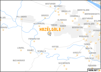
Hazeldale (Oregon, United States - USA)Hazeldale is a town in the Oregon region of United States - USA. An overview map of the region around Hazeldale is displayed below.
regional and 3d topo map of Hazeldale, United States - USA ::
Hazeldale airports ::
The nearest airport is PDX - Portland Intl, located 26.7 km north east of Hazeldale.
Other airports nearby include MMV - Mackminnville Mc Minnville Muni (35.8 km south west), GRF - Fort Lewis Gray Aaf (180.8 km north), TCM - Tacoma Mc Chord Afb (188.5 km north), SEA - Seattle Tacoma Intl (224.9 km north), Nearby towns ::
Tobias (3.3km north) //
Reedville (3.5km north) //
Aloha (3.7km north east) //
Kinton (5.0km south) //
Huber (4.3km north east) //
Witch Hazel (4.8km north west) //
Farmington (4.7km south west) //
Elmonica (5.9km north east) //
Orenco (7.0km north) //
Scholls (6.9km south) //
Tanasbourne (8.3km north) //
Midway (8.1km south west) //
Marlene Village (8.0km north east) //
Oak Hills (9.2km north east) //
[all distances 'as the bird flies' and approximate]  Places with similar names to Hazeldale, United States - USA ::
// Hazeldell (US)
// Hazel Dell (US)
// Hazeldell (US)
// Hazel Dell (US)
// Hazeldell (US)
// Hazel Dell (US)
Disclaimer :: Information on this page comes without warranty of any kind |
||
|
Where is Hazeldale? Elevation and coordinates ::
Latitude (lat): 45°28'0"N Longitude (lon): 122°53'31"W
Elevation (approx.): 77m (map arrows pan, magnifying glasses zoom) |
||
|
Visiting Hazeldale? Hotel/Accommodation ::
Book a hotel in Hazeldale Travel Guide ::
rental cars ::
car rental offers GPS waypoint ::
download a GPX waypoint (PoI) of Hazeldale for your GPS receiver
|
||