|
search place name
|
||
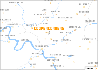
Cooper Corners (Pennsylvania, United States - USA)Cooper Corners is a town in the Pennsylvania region of United States - USA. An overview map of the region around Cooper Corners is displayed below.
regional and 3d topo map of Cooper Corners, United States - USA ::
Cooper Corners airports ::
The nearest airport is IPT - Williamsport Rgnl, located 91.8 km south west of Cooper Corners.
Other airports nearby include MUI - Muir Aaf (139.1 km south west), SWF - Newburgh Stewart Intl (152.0 km east), NXX - Willow Grove Nas Jrb (167.4 km south east), SYR - Syracuse Hancock Intl (169.9 km north), Nearby towns ::
Lake Carey (1.3km north west) //
Marcy (1.7km south) //
Brookside (1.7km south west) //
Aldovin (3.5km north) //
Lemon (3.5km north west) //
Dixon (4.0km south east) //
Avery (5.7km north) //
Tunkhannock (5.8km south) //
East Lemon (4.8km east) //
Kaiserville (5.6km north west) //
Bardwell (5.9km south east) //
Lymanville (7.2km north) //
East Lynn (8.1km north) //
West Nicholson (7.4km north east) //
Lynn (8.6km north) //
Osterhout (8.9km south) //
Eatonville (8.7km south) //
[all distances 'as the bird flies' and approximate]  Places with similar names to Cooper Corners, United States - USA :: Disclaimer :: Information on this page comes without warranty of any kind |
||
|
Where is Cooper Corners? Elevation and coordinates ::
Latitude (lat): 41°35'16"N Longitude (lon): 75°55'25"W
Elevation (approx.): 292m (map arrows pan, magnifying glasses zoom) |
||
|
Visiting Cooper Corners? Hotel/Accommodation ::
Book a hotel in Cooper Corners Travel Guide ::
rental cars ::
car rental offers GPS waypoint ::
download a GPX waypoint (PoI) of Cooper Corners for your GPS receiver
|
||