|
search place name
|
||
Dry Run (Pennsylvania, United States - USA)Dry Run is a town in the Pennsylvania region of United States - USA. An overview map of the region around Dry Run is displayed below.
regional and 3d topo map of Dry Run, United States - USA ::

Dry Run airports ::
The nearest airport is AOO - Altoona Blair Co, located 50.2 km west of Dry Run.
Other airports nearby include MDT - Harrisburg Intl (84.4 km east), MUI - Muir Aaf (105.0 km east), IAD - Washington Dulles Intl (138.2 km south), IPT - Williamsport Rgnl (138.5 km north east), Nearby towns ::
Spring Run (3.3km south west) //
Newbridge (3.3km south east) //
Doylestown (4.3km north east) //
Laurel Grove (4.0km south east) //
Stony Point (6.1km south west) //
Nossville (7.4km north) //
Willow Hill (7.2km south west) //
Neelyton (5.9km west) //
Doylesburg (6.9km north east) //
Amberson (6.5km east) //
Mountain Green (7.5km south west) //
[all distances 'as the bird flies' and approximate] 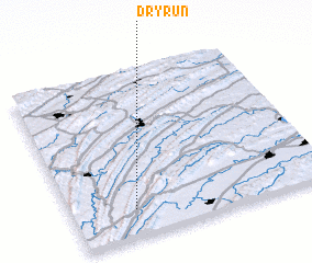 Places with similar names to Dry Run, United States - USA ::
Disclaimer :: Information on this page comes without warranty of any kind |
||
|
Where is Dry Run? Elevation and coordinates ::
Latitude (lat): 40°10'3"N Longitude (lon): 77°45'15"W
Elevation (approx.): 276m (map arrows pan, magnifying glasses zoom) |
||
|
Visiting Dry Run? Hotel/Accommodation ::
Book a hotel in Dry Run Travel Guide ::
rental cars ::
car rental offers GPS waypoint ::
download a GPX waypoint (PoI) of Dry Run for your GPS receiver
|
||