|
search place name
|
||
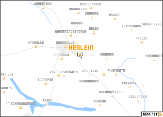
Henlein (Pennsylvania, United States - USA)Henlein is a town in the Pennsylvania region of United States - USA. An overview map of the region around Henlein is displayed below.
regional and 3d topo map of Henlein, United States - USA ::
Henlein airports ::
The nearest airport is YNG - Youngstown Warren Rgnl, located 30.0 km south west of Henlein.
Other airports nearby include PIT - Pittsburgh (pennsylva) Pittsburgh Intl (99.3 km south), AKR - Akron Fulton Intl (100.5 km west), CLE - Cleveland Hopkins Intl (124.8 km west), YXU - London (195.3 km north), Nearby towns ::
Oniontown (4.0km south) //
Greenville (3.9km north west) //
Shenango (3.5km west) //
Reynolds Heights (5.0km south west) //
Donner Crossroads (5.6km north) //
Kashner (4.4km east) //
Leechs Corners (6.0km north) //
Kremis (5.3km south east) //
New Hamburg (6.3km south) //
Greencrest Park (5.5km south west) //
Salem (6.4km north) //
Osgood (7.2km north) //
Five Points (7.0km south east) //
Transfer (8.5km south west) //
Delaware Grove (10.0km south east) //
[all distances 'as the bird flies' and approximate]  Places with similar names to Henlein, United States - USA ::
Disclaimer :: Information on this page comes without warranty of any kind |
||
|
Where is Henlein? Elevation and coordinates ::
Latitude (lat): 41°22'49"N Longitude (lon): 80°21'28"W
Elevation (approx.): 346m (map arrows pan, magnifying glasses zoom) |
||
|
Visiting Henlein? Hotel/Accommodation ::
Book a hotel in Henlein Travel Guide ::
rental cars ::
car rental offers GPS waypoint ::
download a GPX waypoint (PoI) of Henlein for your GPS receiver
|
||