|
search place name
|
||
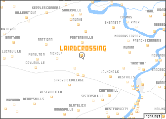
Laird Crossing (Pennsylvania, United States - USA)Laird Crossing is a town in the Pennsylvania region of United States - USA. An overview map of the region around Laird Crossing is displayed below.
regional and 3d topo map of Laird Crossing, United States - USA ::
Laird Crossing airports ::
The nearest airport is PIT - Pittsburgh (pennsylva) Pittsburgh Intl, located 65.9 km south west of Laird Crossing.
Other airports nearby include YNG - Youngstown Warren Rgnl (98.0 km north west), AOO - Altoona Blair Co (128.1 km south east), AKR - Akron Fulton Intl (155.5 km west), EKN - Elkins Randolph Co Jennings Randolph (220.8 km south), Nearby towns ::
Craigsville (2.4km south west) //
Buffalo Mills (3.5km south) //
Worthington (3.6km south) //
Fosters Mills (3.9km north) //
Cowansville (4.2km north east) //
Nichola (4.4km west) //
Browns Crossroads (6.3km north) //
Shadyside Village (6.2km south) //
Walkchalk (6.1km south east) //
Adams (7.9km north) //
Rattigan (7.1km north west) //
Sherrett (8.8km north east) //
Center Hill (9.3km south east) //
West Winfield (10.0km south west) //
[all distances 'as the bird flies' and approximate]  Places with similar names to Laird Crossing, United States - USA :: Disclaimer :: Information on this page comes without warranty of any kind |
||
|
Where is Laird Crossing? Elevation and coordinates ::
Latitude (lat): 40°52'13"N Longitude (lon): 79°37'59"W
Elevation (approx.): 325m (map arrows pan, magnifying glasses zoom) |
||
|
Visiting Laird Crossing? Hotel/Accommodation ::
Book a hotel in Laird Crossing Travel Guide ::
rental cars ::
car rental offers GPS waypoint ::
download a GPX waypoint (PoI) of Laird Crossing for your GPS receiver
|
||