|
search place name
|
||
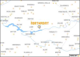
North Point (Pennsylvania, United States - USA)North Point is a town in the Pennsylvania region of United States - USA. An overview map of the region around North Point is displayed below.
regional and 3d topo map of North Point, United States - USA ::
North Point airports ::
The nearest airport is AOO - Altoona Blair Co, located 96.3 km south east of North Point.
Other airports nearby include PIT - Pittsburgh (pennsylva) Pittsburgh Intl (103.7 km south west), YNG - Youngstown Warren Rgnl (135.9 km west), IAD - Washington Dulles Intl (260.5 km south east), Nearby towns ::
Loop (2.9km west) //
Porter (4.6km north west) //
Smicksburg (5.0km south west) //
Hamilton (4.8km north east) //
Trade City (5.5km south east) //
Dora (7.4km north) //
McCormick (7.8km south) //
Wells (8.4km south) //
Sunrise (8.1km north) //
Rossmoyne (8.8km south) //
Georgeville (8.4km south) //
Corbettown (8.2km north west) //
Timblin (8.9km north west) //
Denton (9.5km south west) //
Mottarns Mill (9.8km south east) //
[all distances 'as the bird flies' and approximate]  Places with similar names to North Point, United States - USA ::
// Northpoint (US)
// North Point (US)
// North Pointe (US)
// North Point (US)
// North Point (US)
// North Point (US)
// North Point (US)
// North Point (US)
// Northpoint (US)
// North Pond (US)
Disclaimer :: Information on this page comes without warranty of any kind |
||
|
Where is North Point? Elevation and coordinates ::
Latitude (lat): 40°54'13"N Longitude (lon): 79°7'54"W
Elevation (approx.): 357m (map arrows pan, magnifying glasses zoom) |
||
|
Visiting North Point? Hotel/Accommodation ::
Book a hotel in North Point Travel Guide ::
rental cars ::
car rental offers GPS waypoint ::
download a GPX waypoint (PoI) of North Point for your GPS receiver
|
||