|
search place name
|
||
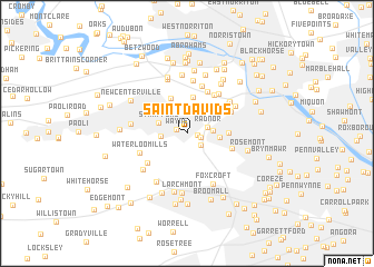
Saint Davids (Pennsylvania, United States - USA)Saint Davids is a town in the Pennsylvania region of United States - USA. An overview map of the region around Saint Davids is displayed below.
regional and 3d topo map of Saint Davids, United States - USA ::
Saint Davids airports ::
The nearest airport is PHL - Philadelphia Intl, located 22.1 km south east of Saint Davids.
Other airports nearby include NXX - Willow Grove Nas Jrb (26.4 km north east), ILG - Wilmington New Castle (44.7 km south west), TTN - Trenton Mercer (54.8 km north east), WRI - Wrightstown Mc Guire Afb (67.3 km east), Nearby towns ::
Wayne (0.9km north west) //
Radnor Station (0.9km east) //
Willowburn (1.1km south east) //
Ithan (1.6km south east) //
Radnor (1.7km east) //
West Wayne (2.0km west) //
Upton (2.1km east) //
Strafford (2.5km north west) //
Villanova (2.5km east) //
Bob White Farms (3.6km north) //
Colonial Village (3.8km north) //
Rampart Ridge (3.5km north east) //
Saint Marys Seminary (3.2km east) //
Gulph Mills Village (4.5km north) //
Merion Hills (4.3km north east) //
Garrett Hill (3.8km south east) //
Conshohocken Station (4.0km north east) //
Aronwold (4.2km south west) //
Valley Forge Acres (4.9km north) //
Waterloo Mills (4.1km south west) //
School Side Manor (4.7km north east) //
Valley Forge Homes (5.3km north) //
Gulph Mills (4.6km north east) //
Gulph Terrace (4.6km north east) //
Foxcroft (5.4km south) //
Devon (4.4km west) //
King of Prussia (5.6km north) //
Wyola (5.0km south west) //
Central Square (5.5km south west) //
[all distances 'as the bird flies' and approximate]  Places with similar names to Saint Davids, United States - USA ::
// Saint Davids (BB)
// Saint Davidʼs (IE)
// Saint Davids (GB)
// Saint Davids (CA)
// Saint Davids (GB)
Disclaimer :: Information on this page comes without warranty of any kind |
||
|
Where is Saint Davids? Elevation and coordinates ::
Latitude (lat): 40°2'27"N Longitude (lon): 75°22'44"W
Elevation (approx.): 115m (map arrows pan, magnifying glasses zoom) |
||
|
Visiting Saint Davids? Hotel/Accommodation ::
Book a hotel in Saint Davids Travel Guide ::
rental cars ::
car rental offers GPS waypoint ::
download a GPX waypoint (PoI) of Saint Davids for your GPS receiver
|
||