|
search place name
|
||
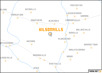
Wilson Mills (Pennsylvania, United States - USA)Wilson Mills is a town in the Pennsylvania region of United States - USA. An overview map of the region around Wilson Mills is displayed below.
regional and 3d topo map of Wilson Mills, United States - USA ::
Wilson Mills airports ::
The nearest airport is YNG - Youngstown Warren Rgnl, located 71.8 km south west of Wilson Mills.
Other airports nearby include PIT - Pittsburgh (pennsylva) Pittsburgh Intl (120.6 km south), AKR - Akron Fulton Intl (142.2 km south west), CLE - Cleveland Hopkins Intl (162.6 km west), YHM - Hamilton (180.4 km north), Nearby towns ::
East Wayne (2.5km north) //
Black Ash (4.7km north) //
Plum Corner (4.3km south east) //
Bradleytown (4.2km east) //
Mount Hope (6.3km north west) //
Cooperstown (6.6km south east) //
Deckard (6.1km south west) //
Sunville (6.3km east) //
Hannasville (8.6km south) //
Canal Center (8.9km south) //
Chapmanville (7.7km north east) //
Fauncetown (8.9km north east) //
Mason (10.0km south east) //
Luces Corners (9.8km north east) //
[all distances 'as the bird flies' and approximate] 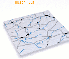 Places with similar names to Wilson Mills, United States - USA :: Disclaimer :: Information on this page comes without warranty of any kind |
||
|
Where is Wilson Mills? Elevation and coordinates ::
Latitude (lat): 41°32'59"N Longitude (lon): 79°54'40"W
Elevation (approx.): 416m (map arrows pan, magnifying glasses zoom) |
||
|
Visiting Wilson Mills? Hotel/Accommodation ::
Book a hotel in Wilson Mills Travel Guide ::
rental cars ::
car rental offers GPS waypoint ::
download a GPX waypoint (PoI) of Wilson Mills for your GPS receiver
|
||