|
search place name
|
||
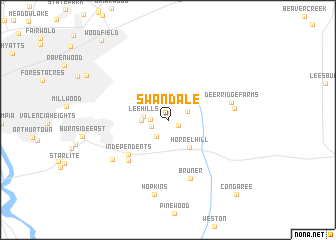
Swandale (South Carolina, United States - USA)Swandale is a town in the South Carolina region of United States - USA. An overview map of the region around Swandale is displayed below.
regional and 3d topo map of Swandale, United States - USA ::
Swandale airports ::
The nearest airport is CAE - Colombia Columbia Metropolitan, located 24.1 km west of Swandale.
Other airports nearby include SSC - Sumter Shaw Afb (36.4 km east), FLO - Florence Rgnl (107.7 km east), AGS - Bush Field Augusta Rgnl At Bush Fld (122.4 km south west), CLT - Charlotte Douglas Intl (137.1 km north), Nearby towns ::
San Marco Estates (1.2km south east) //
Padgett Acres (1.6km west) //
Quail Hills (1.7km south west) //
Quail Creek (2.2km south west) //
Green Lake Estates (2.1km north east) //
Lee Hills (2.3km west) //
Pine Lake (2.5km west) //
Horrel Hill (3.7km south east) //
Independents (5.4km south west) //
Lykes (5.8km south west) //
Bruner (6.8km south) //
Deer Ridge Farms (6.2km east) //
Harmon Estates (6.3km east) //
Mill Creek Estates (6.7km south west) //
Hopkins (8.5km south) //
Congaree (10.5km south east) //
Woodfield (10.8km north west) //
[all distances 'as the bird flies' and approximate] 
Disclaimer :: Information on this page comes without warranty of any kind |
||
|
Where is Swandale? Elevation and coordinates ::
Latitude (lat): 33°58'46"N Longitude (lon): 80°51'50"W
Elevation (approx.): 119m (map arrows pan, magnifying glasses zoom) |
||
|
Visiting Swandale? Hotel/Accommodation ::
Book a hotel in Swandale Travel Guide ::
rental cars ::
car rental offers GPS waypoint ::
download a GPX waypoint (PoI) of Swandale for your GPS receiver
|
||