|
search place name
|
||
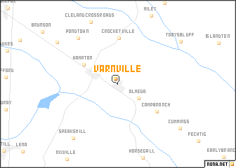
Varnville (South Carolina, United States - USA)Varnville is a town in the South Carolina region of United States - USA. An overview map of the region around Varnville is displayed below.
regional and 3d topo map of Varnville, United States - USA ::
Varnville airports ::
The nearest airport is NBC - Beaufort Mcas, located 53.2 km south east of Varnville.
Other airports nearby include SAV - Savannah Hilton Head Intl (81.0 km south), SVN - Hunter Aaf (93.4 km south), CHS - Charleston Afb Intl (97.4 km east), AGS - Bush Field Augusta Rgnl At Bush Fld (100.7 km north west), Nearby towns ::
Almeda (3.6km south east) //
Hampton (5.5km north west) //
Crocketville (7.4km north) //
Camp Branch (6.9km south east) //
Pond Town (9.0km north west) //
Speaks Mill (10.5km south west) //
[all distances 'as the bird flies' and approximate]  Places with similar names to Varnville, United States - USA ::
// Fern Valley (US)
// Fearnowville (US)
// Fern Valley (US)
// Fernvale (US)
// Fernville (US)
// Fernvale (US)
// Fernville (US)
// Fourneville (FR)
// Fournival (FR)
// Varnéville (FR)
Disclaimer :: Information on this page comes without warranty of any kind |
||
|
Where is Varnville? Elevation and coordinates ::
Latitude (lat): 32°51'1"N Longitude (lon): 81°4'46"W
Elevation (approx.): 34m (map arrows pan, magnifying glasses zoom) |
||
|
Visiting Varnville? Hotel/Accommodation ::
Book a hotel in Varnville Travel Guide ::
rental cars ::
car rental offers GPS waypoint ::
download a GPX waypoint (PoI) of Varnville for your GPS receiver
|
||