|
search place name
|
||
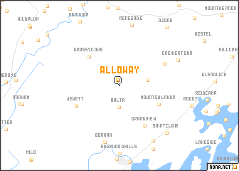
Alloway (Tennessee, United States - USA)Alloway is a town in the Tennessee region of United States - USA. An overview map of the region around Alloway is displayed below.
regional and 3d topo map of Alloway, United States - USA ::
Alloway airports ::
The nearest airport is TYS - Knoxville Mc Ghee Tyson, located 79.7 km east of Alloway.
Other airports nearby include CHA - Chattanooga Lovell Fld (89.9 km south), BNA - Nashville Intl (166.5 km west), HUA - Redstone Aaf (206.4 km south west), MGE - Marietta Dobbins Arb (Atlanta Nas) (211.6 km south), Nearby towns ::
Balta (3.5km south) //
Mount Zion (3.6km east) //
Grassy Cove (5.9km north west) //
Mount Sulphur (5.8km south east) //
Grandview (7.0km south east) //
Jewett (6.3km south west) //
Dogwood (6.7km north east) //
Bonham (9.0km south) //
Lorraine (9.7km south east) //
Saint Clair (9.6km south east) //
[all distances 'as the bird flies' and approximate] 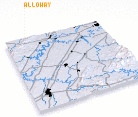 Places with similar names to Alloway, United States - USA ::
Disclaimer :: Information on this page comes without warranty of any kind |
||
|
Where is Alloway? Elevation and coordinates ::
Latitude (lat): 35°48'0"N Longitude (lon): 84°52'32"W
Elevation (approx.): 457m (map arrows pan, magnifying glasses zoom) |
||
|
Visiting Alloway? Hotel/Accommodation ::
Book a hotel in Alloway Travel Guide ::
rental cars ::
car rental offers GPS waypoint ::
download a GPX waypoint (PoI) of Alloway for your GPS receiver
|
||