|
search place name
|
||
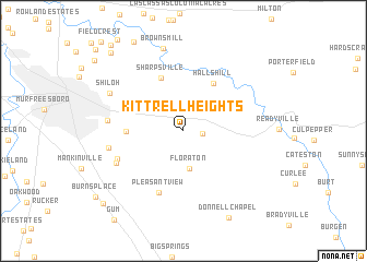
Kittrell Heights (Tennessee, United States - USA)Kittrell Heights is a town in the Tennessee region of United States - USA. An overview map of the region around Kittrell Heights is displayed below.
regional and 3d topo map of Kittrell Heights, United States - USA ::
Kittrell Heights airports ::
The nearest airport is BNA - Nashville Intl, located 50.0 km north west of Kittrell Heights.
Other airports nearby include CHA - Chattanooga Lovell Fld (130.2 km south east), HUA - Redstone Aaf (133.0 km south), HOP - Hopkinsville Campbell Aaf (145.0 km north west), MGE - Marietta Dobbins Arb (Atlanta Nas) (265.4 km south east), Nearby towns ::
Kittrell (1.6km east) //
Floraton (3.8km south) //
Halls Hill (5.4km north east) //
Sharpsville (5.7km north) //
Overall Acres (4.7km west) //
Pleasant View (6.6km south) //
Dillton (6.2km south west) //
Fox Camp Meadows (6.5km south west) //
Twin Springs (6.4km west) //
Double Springs (6.4km west) //
Shiloh (7.2km north west) //
Browns Mill (8.6km north) //
Donnell Chapel (9.7km south east) //
Two Hills (10.0km north west) //
Mount Tabor (10.0km south west) //
Compton (10.6km north west) //
[all distances 'as the bird flies' and approximate] 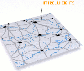 Places with similar names to Kittrell Heights, United States - USA :: Disclaimer :: Information on this page comes without warranty of any kind |
||
|
Where is Kittrell Heights? Elevation and coordinates ::
Latitude (lat): 35°49'35"N Longitude (lon): 86°15'45"W
Elevation (approx.): 192m (map arrows pan, magnifying glasses zoom) |
||
|
Visiting Kittrell Heights? Hotel/Accommodation ::
Book a hotel in Kittrell Heights Travel Guide ::
rental cars ::
car rental offers GPS waypoint ::
download a GPX waypoint (PoI) of Kittrell Heights for your GPS receiver
|
||