|
search place name
|
||
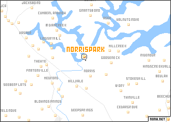
Norris Park (Tennessee, United States - USA)Norris Park is a town in the Tennessee region of United States - USA. An overview map of the region around Norris Park is displayed below.
regional and 3d topo map of Norris Park, United States - USA ::
Norris Park airports ::
The nearest airport is TYS - Knoxville Mc Ghee Tyson, located 46.6 km south of Norris Park.
Other airports nearby include CHA - Chattanooga Lovell Fld (166.8 km south west), AND - Andersen Anderson Rgnl (228.8 km south east), FTK - Fort Knox Godman Aaf (251.4 km north west), Nearby towns ::
Norris (3.4km south) //
Andersonville (4.7km south east) //
Gooseneck (4.6km east) //
Belmont (4.8km north east) //
Hillvale (5.8km south) //
Bethel (6.0km south) //
Cumberland View Estates (5.8km west) //
Mill Creek (6.2km east) //
Oak Grove (6.7km north west) //
Pine Crest (7.3km north west) //
Lindsay Mill (7.2km north west) //
Offutt (7.8km south west) //
Lake City (6.9km west) //
Medford (7.7km south west) //
Indian Creek (8.4km north west) //
Maples (8.8km south west) //
Agee (9.3km north east) //
Ivory (9.1km south east) //
[all distances 'as the bird flies' and approximate] 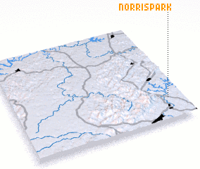 Places with similar names to Norris Park, United States - USA ::
// Narrows Park (US)
Disclaimer :: Information on this page comes without warranty of any kind |
||
|
Where is Norris Park? Elevation and coordinates ::
Latitude (lat): 36°13'30"N Longitude (lon): 84°4'41"W
Elevation (approx.): 374m (map arrows pan, magnifying glasses zoom) |
||
|
Visiting Norris Park? Hotel/Accommodation ::
Book a hotel in Norris Park Travel Guide ::
rental cars ::
car rental offers GPS waypoint ::
download a GPX waypoint (PoI) of Norris Park for your GPS receiver
|
||