|
search place name
|
||
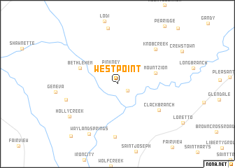
Westpoint (Tennessee, United States - USA)Westpoint is a town in the Tennessee region of United States - USA. An overview map of the region around Westpoint is displayed below.
regional and 3d topo map of Westpoint, United States - USA ::
Westpoint airports ::
The nearest airport is HUA - Redstone Aaf, located 92.5 km south east of Westpoint.
Other airports nearby include BNA - Nashville Intl (134.6 km north east), MKL - Jackson Mc Kellar Sipes Rgnl (135.9 km north west), HOP - Hopkinsville Campbell Aaf (170.4 km north), CBM - Colombus Columbus Afb (185.2 km south west), Nearby towns ::
Chinubee (1.8km south east) //
Pinkney (2.8km north) //
Mount Zion (5.2km east) //
Bethlehem (5.5km north west) //
Clack Branch (6.8km south east) //
Knob Creek (7.4km north east) //
Mount Nebo (8.4km south) //
Upper Holly Creek (7.2km west) //
Wayland Springs (8.8km south west) //
Holly Creek (8.1km south west) //
Lower Holly Creek (10.3km south west) //
[all distances 'as the bird flies' and approximate] 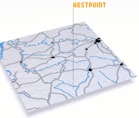 Places with similar names to Westpoint, United States - USA ::
// West Point (US)
// West Point (US)
// West Point (US)
// West Point (US)
// West Point (US)
// West Point (US)
// West Point (US)
// West Point (US)
// West Point (US)
// Westpoint (US)
Disclaimer :: Information on this page comes without warranty of any kind |
||
|
Where is Westpoint? Elevation and coordinates ::
Latitude (lat): 35°7'59"N Longitude (lon): 87°32'1"W
Elevation (approx.): 187m (map arrows pan, magnifying glasses zoom) |
||
|
Visiting Westpoint? Hotel/Accommodation ::
Book a hotel in Westpoint Travel Guide ::
rental cars ::
car rental offers GPS waypoint ::
download a GPX waypoint (PoI) of Westpoint for your GPS receiver
|
||