|
search place name
|
||
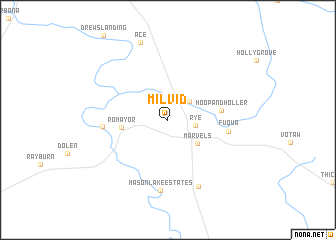
Milvid (Texas, United States - USA)Milvid is a town in the Texas region of United States - USA. An overview map of the region around Milvid is displayed below.
regional and 3d topo map of Milvid, United States - USA ::
Milvid airports ::
The nearest airport is CXO - Conroe Lone Star Executive, located 60.6 km west of Milvid.
Other airports nearby include IAH - George Bush Intcntl Houston (74.3 km south west), BPT - Beaumont Southeast Texas Rgnl (93.5 km south east), HOU - Houston William P Hobby (101.4 km south west), GLS - Scholes Intl At Galveston (132.4 km south), Nearby towns ::
Rye (2.7km east) //
Big Thicket Creekmore Village (2.9km north east) //
Marvels (3.9km south east) //
Romayor (4.5km west) //
Hoop and Holler (5.2km east) //
Fuqua (5.9km east) //
Big Creek (6.4km west) //
Mason Lake Estates (7.9km south) //
Clark (7.9km south) //
Ace (9.0km north) //
[all distances 'as the bird flies' and approximate]  Places with similar names to Milvid, United States - USA ::
// Moulvouday (CM)
// Mályvád (HU)
// Milvydai (LT)
// Malovăţ (RO)
// Molovatyy (UA)
// Malvedo (ES)
// Malyy Uvat (RU)
// Melivato (MG)
// Malvado (US)
// Mulāghāta (BD)
Disclaimer :: Information on this page comes without warranty of any kind |
||
|
Where is Milvid? Elevation and coordinates ::
Latitude (lat): 30°27'30"N Longitude (lon): 94°47'47"W
Elevation (approx.): 31m (map arrows pan, magnifying glasses zoom) |
||
|
Visiting Milvid? Hotel/Accommodation ::
Book a hotel in Milvid Travel Guide ::
rental cars ::
car rental offers GPS waypoint ::
download a GPX waypoint (PoI) of Milvid for your GPS receiver
|
||