|
search place name
|
||
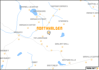
North Walden (Vermont, United States - USA)North Walden is a town in the Vermont region of United States - USA. An overview map of the region around North Walden is displayed below.
regional and 3d topo map of North Walden, United States - USA ::
North Walden airports ::
The nearest airport is BTV - Burlington Intl, located 70.9 km west of North Walden.
Other airports nearby include YSC - Sherbrooke (113.1 km north east), YJN - St. Jean St Jean (119.0 km north west), YHU - Montreal St Hubert (144.7 km north west), YUL - Montreal Pierre Elliott Trudeau Intl (158.4 km north west), Nearby towns ::
Dows Crossing (1.9km west) //
Taylor Bridge (3.3km south west) //
Smith Corner (4.3km south) //
South Walden (4.0km south west) //
Greensboro Bend (4.9km north) //
East Hardwick (4.1km north west) //
Walden Heights (5.9km south) //
Hardwick Street (5.7km north west) //
Goslants Mill (5.7km south east) //
Stannard (5.7km north east) //
East Greensboro (7.4km north) //
Walden (6.9km south east) //
Nevesville (6.9km south east) //
Tolman Corner (7.8km north west) //
Hardwick Center (6.5km north west) //
Greensboro (8.3km north) //
[all distances 'as the bird flies' and approximate] 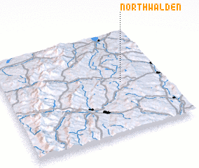 Places with similar names to North Walden, United States - USA ::
// North Wilton (US)
// North Welton (US)
Disclaimer :: Information on this page comes without warranty of any kind |
||
|
Where is North Walden? Elevation and coordinates ::
Latitude (lat): 44°30'18"N Longitude (lon): 72°15'49"W
Elevation (approx.): 507m (map arrows pan, magnifying glasses zoom) |
||
|
Visiting North Walden? Hotel/Accommodation ::
Book a hotel in North Walden Travel Guide ::
rental cars ::
car rental offers GPS waypoint ::
download a GPX waypoint (PoI) of North Walden for your GPS receiver
|
||