|
search place name
|
||
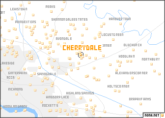
Cherrydale (Virginia, United States - USA)Cherrydale is a town in the Virginia region of United States - USA. An overview map of the region around Cherrydale is displayed below.
regional and 3d topo map of Cherrydale, United States - USA ::
Cherrydale airports ::
The nearest airport is RIC - Richmond Intl, located 13.4 km south of Cherrydale.
Other airports nearby include PHF - Newport News Williamsburg Intl (91.8 km south east), LFI - Hampton Langley Afb (104.6 km south east), NHK - Patuxent River Nas (108.7 km north east), NGU - Norfolk Ns (119.5 km south east), Nearby towns ::
Cherrydale West (0.3km north west) //
Fieldshire (0.5km north) //
Raven Run (1.0km north east) //
Dogwood Knoll (1.2km south west) //
Hundleys Corner (1.5km north) //
Battlefield Green (1.3km east) //
Pole Green (1.6km north west) //
Heatherwood (2.2km north) //
Brandy Creek Estates (2.3km south) //
Pine Hill (2.5km north) //
Strawhorn (2.7km north) //
Bell Creek North (2.2km west) //
Newman (2.3km east) //
Spring Meadows (2.5km south west) //
Meadow Gate (2.5km west) //
Stonewall Estates (3.0km south east) //
Walnut Grove (3.2km south west) //
Mattawan (3.8km north) //
Cold Harbor Farms (3.9km south) //
Simpkins Corner (4.0km south) //
Hughes Corner (3.8km north east) //
Orchard Gardens (3.9km east) //
Gaines Mill (4.7km south east) //
Ellerson Mill (4.5km south west) //
Pebblebrook (5.4km north) //
Avondale (4.8km north west) //
Rainier Estates (5.2km north east) //
Robin Ridge (4.8km north west) //
Hanover Farms (5.3km south east) //
[all distances 'as the bird flies' and approximate] 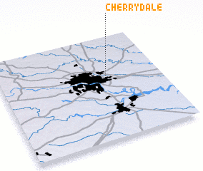 Places with similar names to Cherrydale, United States - USA ::
// Shortly (US)
// Chertaly (RU)
// Sherdahl (US)
// Chartley (US)
// Chartley (US)
// Cherry Dale (US)
// Shortall (US)
// Cherrydale (US)
// Chāritala (BD)
// Char Tilli (BD)
Disclaimer :: Information on this page comes without warranty of any kind |
||
|
Where is Cherrydale? Elevation and coordinates ::
Latitude (lat): 37°37'33"N Longitude (lon): 77°19'30"W
Elevation (approx.): 56m (map arrows pan, magnifying glasses zoom) |
||
|
Visiting Cherrydale? Hotel/Accommodation ::
Book a hotel in Cherrydale Travel Guide ::
rental cars ::
car rental offers GPS waypoint ::
download a GPX waypoint (PoI) of Cherrydale for your GPS receiver
|
||