|
search place name
|
||
Chincoteague (Virginia, United States - USA)Chincoteague is a town in the Virginia region of United States - USA. An overview map of the region around Chincoteague is displayed below.
regional and 3d topo map of Chincoteague, United States - USA ::

Chincoteague airports ::
The nearest airport is SBY - Salisbury Ocean City Wicomico Rgnl, located 46.7 km north of Chincoteague.
Other airports nearby include NHK - Patuxent River Nas (98.7 km north west), WWD - Wildwood Cape May Co (126.3 km north), LFI - Hampton Langley Afb (128.2 km south west), PHF - Newport News Williamsburg Intl (132.7 km south west), Nearby towns ::
Birch Town (1.7km south east) //
Black Point Landing (2.7km south) //
Deep Hole (2.3km east) //
Sinnickson (7.4km north west) //
Franklin City (8.3km north) //
Greenbackville (8.8km north) //
[all distances 'as the bird flies' and approximate] 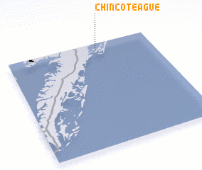 Places with similar names to Chincoteague, United States - USA ::
// Changdŏk (KP)
// Changdŏk (KP)
// Changdŏk (KP)
// Changgaedŏk (KP)
// Ch'unggudŏk (KP)
// Changdŏk (KR)
// Chŏngt'ak (KR)
// Shang-ta-k'u (TW)
// Shuang-t'ou-kua (TW)
// Ch'angdŏk (KP)
Disclaimer :: Information on this page comes without warranty of any kind |
||
|
Where is Chincoteague? Elevation and coordinates ::
Latitude (lat): 37°55'59"N Longitude (lon): 75°22'45"W
Elevation (approx.): 1m (map arrows pan, magnifying glasses zoom) |
||
|
Visiting Chincoteague? Hotel/Accommodation ::
Book a hotel in Chincoteague Travel Guide ::
rental cars ::
car rental offers GPS waypoint ::
download a GPX waypoint (PoI) of Chincoteague for your GPS receiver
|
||