|
search place name
|
||
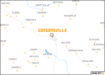
Gordonsville (Virginia, United States - USA)Gordonsville is a town in the Virginia region of United States - USA. An overview map of the region around Gordonsville is displayed below.
regional and 3d topo map of Gordonsville, United States - USA ::
Gordonsville airports ::
The nearest airport is RIC - Richmond Intl, located 103.8 km south east of Gordonsville.
Other airports nearby include IAD - Washington Dulles Intl (110.0 km north east), DCA - Ronald Reagan Washington Natl (127.9 km north east), ADW - Camp Springs Andrews Afb (Washington Dc Naf) (137.4 km north east), NHK - Patuxent River Nas (156.4 km east), Nearby towns ::
Meltons (4.9km south east) //
Waldrop (7.2km south) //
Lindsay (7.5km south west) //
Somerset (8.3km north) //
Tibbstown (7.9km north west) //
Madison Run (8.3km north east) //
Whitlock (9.3km south west) //
Green Springs (8.8km south east) //
Cobham Park (10.9km south west) //
[all distances 'as the bird flies' and approximate] 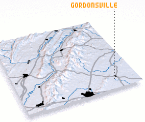 Places with similar names to Gordonsville, United States - USA ::
Disclaimer :: Information on this page comes without warranty of any kind |
||
|
Where is Gordonsville? Elevation and coordinates ::
Latitude (lat): 38°8'14"N Longitude (lon): 78°11'17"W
Elevation (approx.): 148m (map arrows pan, magnifying glasses zoom) |
||
|
Visiting Gordonsville? Hotel/Accommodation ::
Book a hotel in Gordonsville Travel Guide ::
rental cars ::
car rental offers GPS waypoint ::
download a GPX waypoint (PoI) of Gordonsville for your GPS receiver
|
||