|
search place name
|
||
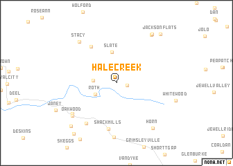
Hale Creek (Virginia, United States - USA)Hale Creek is a town in the Virginia region of United States - USA. An overview map of the region around Hale Creek is displayed below.
regional and 3d topo map of Hale Creek, United States - USA ::
Hale Creek airports ::
The nearest airport is HKY - Hickory Rgnl, located 175.8 km south of Hale Creek.
Other airports nearby include INT - Winston-salem Smith Reynolds (198.2 km south east), Nearby towns ::
Dwight (1.4km east) //
Patterson (3.0km west) //
Roth (3.2km south west) //
Slate (5.0km north) //
Matney (6.7km north west) //
Shack Mills (7.5km south) //
Keen Mountain (7.6km south west) //
Hanger (7.5km south west) //
Marvin (8.8km south) //
Oakwood (7.7km south west) //
Stacy (8.2km north west) //
Horn (8.6km south east) //
Paynesville (9.0km north east) //
Paynesville (9.1km north east) //
Mavisdale (9.1km south west) //
Jackson Flats (9.6km north east) //
Mount Heron (9.8km south west) //
[all distances 'as the bird flies' and approximate]  Places with similar names to Hale Creek, United States - USA ::
// Hall Creek (US)
// Hill Creek (US)
// Hallack Rock (ZA)
// Hollow Creek (US)
// Holly Creek (US)
// Hollow Creek (US)
// Hollow Creek (US)
// Holly Creek (US)
// Halkirk (CA)
// Haly Creek (AU)
Disclaimer :: Information on this page comes without warranty of any kind |
||
|
Where is Hale Creek? Elevation and coordinates ::
Latitude (lat): 37°15'40"N Longitude (lon): 81°56'34"W
Elevation (approx.): 469m (map arrows pan, magnifying glasses zoom) |
||
|
Visiting Hale Creek? Hotel/Accommodation ::
Book a hotel in Hale Creek Travel Guide ::
rental cars ::
car rental offers GPS waypoint ::
download a GPX waypoint (PoI) of Hale Creek for your GPS receiver
|
||