|
search place name
|
||
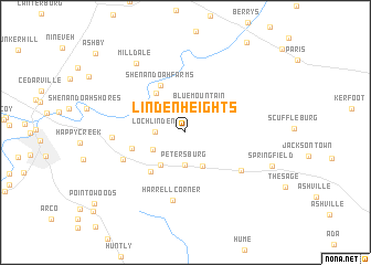
Linden Heights (Virginia, United States - USA)Linden Heights is a town in the Virginia region of United States - USA. An overview map of the region around Linden Heights is displayed below.
regional and 3d topo map of Linden Heights, United States - USA ::
Linden Heights airports ::
The nearest airport is IAD - Washington Dulles Intl, located 51.8 km east of Linden Heights.
Other airports nearby include DCA - Ronald Reagan Washington Natl (88.6 km east), ADW - Camp Springs Andrews Afb (Washington Dc Naf) (103.9 km east), BWI - Baltimore Washington Intl (122.7 km east), AOO - Altoona Blair Co (152.4 km north), Nearby towns ::
Blue Mountain (2.9km north east) //
Loch Linden (2.4km west) //
Petersburg (3.3km south) //
Skyland Estates (3.1km south west) //
Belle Meade (3.7km south) //
Linden (3.9km south west) //
Howellsville (4.6km north west) //
Monterey Orchards (4.9km south west) //
Shenandoah Farms (5.1km north) //
Apple Mountain Lake (4.5km west) //
Markham (5.9km south east) //
Applewood (5.7km south west) //
Harrell Corner (6.9km south) //
Apple Mountain Lake West (5.8km west) //
Milldale (8.0km north west) //
Springfield (7.6km south east) //
[all distances 'as the bird flies' and approximate]  Places with similar names to Linden Heights, United States - USA ::
// London Heights (US)
Disclaimer :: Information on this page comes without warranty of any kind |
||
|
Where is Linden Heights? Elevation and coordinates ::
Latitude (lat): 38°56'20"N Longitude (lon): 78°3'12"W
Elevation (approx.): 508m (map arrows pan, magnifying glasses zoom) |
||
|
Visiting Linden Heights? Hotel/Accommodation ::
Book a hotel in Linden Heights Travel Guide ::
rental cars ::
car rental offers GPS waypoint ::
download a GPX waypoint (PoI) of Linden Heights for your GPS receiver
|
||