|
search place name
|
||
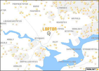
Lorton (Virginia, United States - USA)Lorton is a town in the Virginia region of United States - USA. An overview map of the region around Lorton is displayed below.
regional and 3d topo map of Lorton, United States - USA ::
Lorton airports ::
The nearest airport is DCA - Ronald Reagan Washington Natl, located 23.3 km north east of Lorton.
Other airports nearby include IAD - Washington Dulles Intl (33.2 km north west), ADW - Camp Springs Andrews Afb (Washington Dc Naf) (33.5 km east), BWI - Baltimore Washington Intl (71.4 km north east), NHK - Patuxent River Nas (85.0 km south east), Nearby towns ::
Pohick Estates (2.6km north east) //
Pohick (2.8km east) //
Lorfax Heights (3.0km north west) //
Harbor View (3.7km south) //
Gunston Heights (3.6km south east) //
Colchester (4.0km south) //
Wiley (4.0km south east) //
Occoquan (3.6km south west) //
Chapel Acres (4.4km north) //
Pohick Hills (5.2km north) //
Belmont Park (5.0km south east) //
River Bend Estates (5.4km south) //
Woodbridge (5.5km south) //
Marumsco Village (5.4km south west) //
Newington (5.3km north east) //
Barkers Crossroads (6.1km north) //
Holly Acres Mobile Home Park (6.0km south) //
Hunter Estates (5.6km north east) //
Agnewville (6.4km south west) //
The Heights (6.2km south west) //
Bayside Park (7.5km south) //
Accotink (5.9km east) //
West Springfield (7.6km north) //
Marumsco Acres (7.3km south) //
Beverly Forest (7.3km north east) //
Lake Ridge (6.3km west) //
Westview Hills (8.1km north) //
Bel Air Mobile Home Park (7.7km south west) //
Loisdale Estates (7.6km north east) //
[all distances 'as the bird flies' and approximate]  Places with similar names to Lorton, United States - USA ::
Disclaimer :: Information on this page comes without warranty of any kind |
||
|
Where is Lorton? Elevation and coordinates ::
Latitude (lat): 38°42'15"N Longitude (lon): 77°13'41"W
Elevation (approx.): 44m (map arrows pan, magnifying glasses zoom) |
||
|
Visiting Lorton? Hotel/Accommodation ::
Book a hotel in Lorton Travel Guide ::
rental cars ::
car rental offers GPS waypoint ::
download a GPX waypoint (PoI) of Lorton for your GPS receiver
|
||