|
search place name
|
||
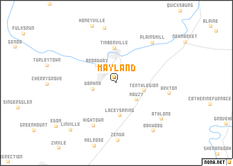
Mayland (Virginia, United States - USA)Mayland is a town in the Virginia region of United States - USA. An overview map of the region around Mayland is displayed below.
regional and 3d topo map of Mayland, United States - USA ::
Mayland airports ::
The nearest airport is EKN - Elkins Randolph Co Jennings Randolph, located 100.1 km west of Mayland.
Other airports nearby include IAD - Washington Dulles Intl (121.0 km east), DCA - Ronald Reagan Washington Natl (153.6 km east), ADW - Camp Springs Andrews Afb (Washington Dc Naf) (167.5 km east), RIC - Richmond Intl (175.2 km south east), Nearby towns ::
Daphna (3.1km west) //
Broadway (3.7km north west) //
Mauzy (3.7km south east) //
Tenth Legion (3.7km east) //
Lacey Spring (5.3km south) //
Timberville (5.6km north) //
Hightown (7.5km south) //
Arkton (6.8km east) //
Plains Mill (7.9km north east) //
Mechanicsville (9.0km north) //
Athlone (8.1km south east) //
Oakwood (9.0km south east) //
Linville (9.5km south west) //
[all distances 'as the bird flies' and approximate]  Places with similar names to Mayland, United States - USA ::
Disclaimer :: Information on this page comes without warranty of any kind |
||
|
Where is Mayland? Elevation and coordinates ::
Latitude (lat): 38°35'18"N Longitude (lon): 78°46'17"W
Elevation (approx.): 375m (map arrows pan, magnifying glasses zoom) |
||
|
Visiting Mayland? Hotel/Accommodation ::
Book a hotel in Mayland Travel Guide ::
rental cars ::
car rental offers GPS waypoint ::
download a GPX waypoint (PoI) of Mayland for your GPS receiver
|
||