|
search place name
|
||
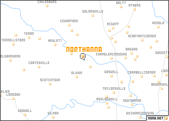
North Anna (Virginia, United States - USA)North Anna is a town in the Virginia region of United States - USA. An overview map of the region around North Anna is displayed below.
regional and 3d topo map of North Anna, United States - USA ::
North Anna airports ::
The nearest airport is RIC - Richmond Intl, located 46.2 km south of North Anna.
Other airports nearby include NHK - Patuxent River Nas (106.5 km north east), DCA - Ronald Reagan Washington Natl (114.7 km north), ADW - Camp Springs Andrews Afb (Washington Dc Naf) (116.9 km north east), IAD - Washington Dulles Intl (117.1 km north), Nearby towns ::
Verdon (1.8km south east) //
Noel (2.8km north west) //
Oliver (3.9km south) //
Chandler Crossing (4.7km east) //
Houstons Corner (5.9km north) //
Doswell (5.8km south east) //
Coffey Corner (7.0km north) //
Hewlett (6.2km north west) //
Patersons Corner (6.9km north east) //
Ruther Glen (6.9km north east) //
Cedar Fork (8.3km north) //
Moncure Corner (8.0km north east) //
Scotchtown (8.0km south west) //
Gum Tree (8.8km south east) //
Garnett Crossing (8.0km south east) //
McDuff (8.7km north east) //
Taylorsville (8.8km south east) //
[all distances 'as the bird flies' and approximate] 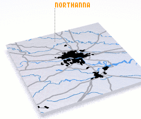 Places with similar names to North Anna, United States - USA ::
Disclaimer :: Information on this page comes without warranty of any kind |
||
|
Where is North Anna? Elevation and coordinates ::
Latitude (lat): 37°53'27"N Longitude (lon): 77°31'4"W
Elevation (approx.): 69m (map arrows pan, magnifying glasses zoom) |
||
|
Visiting North Anna? Hotel/Accommodation ::
Book a hotel in North Anna Travel Guide ::
rental cars ::
car rental offers GPS waypoint ::
download a GPX waypoint (PoI) of North Anna for your GPS receiver
|
||