|
search place name
|
||
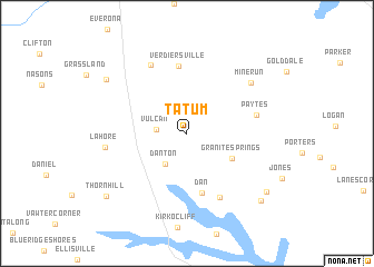
Tatum (Virginia, United States - USA)Tatum is a town in the Virginia region of United States - USA. An overview map of the region around Tatum is displayed below.
regional and 3d topo map of Tatum, United States - USA ::
Tatum airports ::
The nearest airport is IAD - Washington Dulles Intl, located 90.0 km north east of Tatum.
Other airports nearby include RIC - Richmond Intl (93.3 km south east), DCA - Ronald Reagan Washington Natl (103.2 km north east), ADW - Camp Springs Andrews Afb (Washington Dc Naf) (111.7 km north east), NHK - Patuxent River Nas (130.1 km east), Nearby towns ::
Vulcan (2.4km west) //
Danton (3.6km south west) //
Granite Springs (4.4km south east) //
Dan (6.1km south) //
Verdiersville (6.8km north) //
Belmont (6.9km south) //
Paytes (5.7km east) //
Rhoadesville (7.5km north west) //
Mine Run (7.2km north east) //
Lahore (6.6km west) //
Unionville (8.4km north west) //
Bells Crossroad (8.6km south east) //
Stubbs (8.9km south east) //
Thornhill (9.0km south west) //
[all distances 'as the bird flies' and approximate] 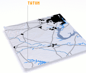 Places with similar names to Tatum, United States - USA ::
Disclaimer :: Information on this page comes without warranty of any kind |
||
|
Where is Tatum? Elevation and coordinates ::
Latitude (lat): 38°12'40"N Longitude (lon): 77°53'44"W
Elevation (approx.): 129m (map arrows pan, magnifying glasses zoom) |
||
|
Visiting Tatum? Hotel/Accommodation ::
Book a hotel in Tatum Travel Guide ::
rental cars ::
car rental offers GPS waypoint ::
download a GPX waypoint (PoI) of Tatum for your GPS receiver
|
||