|
search place name
|
||
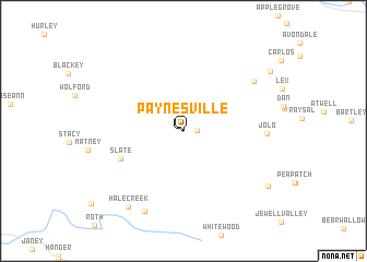
Paynesville (West Virginia, United States - USA)Paynesville is a town in the West Virginia region of United States - USA. An overview map of the region around Paynesville is displayed below.
regional and 3d topo map of Paynesville, United States - USA ::
Paynesville airports ::
The nearest airport is HKY - Hickory Rgnl, located 182.1 km south of Paynesville.
Other airports nearby include INT - Winston-salem Smith Reynolds (199.8 km south east), Nearby towns ::
Paynesville (0.1km north east) //
Jackson Flats (1.1km east) //
Slate (5.8km south west) //
Jolo (6.8km east) //
Rockridge (7.6km north east) //
Dwight (8.8km south) //
Hale Creek (9.0km south west) //
Height (8.9km south east) //
Beartown (9.3km north east) //
[all distances 'as the bird flies' and approximate]  Places with similar names to Paynesville, United States - USA ::
// Pinesville (US)
// Paynesville (US)
// Paynesville (US)
// Paynesville (US)
// Pennsville (US)
// Paynesville (US)
// Pinesville (US)
// Painesville (US)
// Pennsville (US)
// Pennsville (US)
Disclaimer :: Information on this page comes without warranty of any kind |
||
|
Where is Paynesville? Elevation and coordinates ::
Latitude (lat): 37°19'53"N Longitude (lon): 81°53'30"W
Elevation (approx.): 709m (map arrows pan, magnifying glasses zoom) |
||
|
Visiting Paynesville? Hotel/Accommodation ::
Book a hotel in Paynesville Travel Guide ::
rental cars ::
car rental offers GPS waypoint ::
download a GPX waypoint (PoI) of Paynesville for your GPS receiver
|
||