|
search place name
|
||
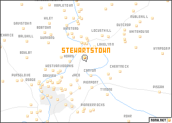
Stewartstown (West Virginia, United States - USA)Stewartstown is a town in the West Virginia region of United States - USA. An overview map of the region around Stewartstown is displayed below.
regional and 3d topo map of Stewartstown, United States - USA ::
Stewartstown airports ::
The nearest airport is EKN - Elkins Randolph Co Jennings Randolph, located 90.5 km south of Stewartstown.
Other airports nearby include PIT - Pittsburgh (pennsylva) Pittsburgh Intl (91.9 km north), AOO - Altoona Blair Co (150.2 km north east), YNG - Youngstown Warren Rgnl (185.0 km north), AKR - Akron Fulton Intl (199.0 km north west), Nearby towns ::
McKinley Hill (2.9km north) //
Davidson (2.7km north east) //
Canyon (3.2km south) //
Hoard (2.7km west) //
Nilan (3.5km north east) //
Point Marion (3.9km north) //
West Point Marion (4.0km north) //
Walnut Hill (4.1km north) //
Jaco (4.4km south) //
Blosser Hill (4.6km north) //
Greater Point Marion (5.1km north) //
Lake Lynn (4.3km north east) //
Sprucetown (5.5km north) //
Fort Martin (4.3km west) //
Sunset Beach (4.7km south east) //
Pierpont (5.7km south) //
Easton (5.8km south) //
Dilliner (5.7km north) //
West Van Voorhis (4.8km south west) //
Fieldcrest (5.7km south west) //
Baker Ridge (5.3km south west) //
Cheat Lake (5.4km south east) //
Van Voorhis (5.2km south west) //
Locust Hill (6.2km north east) //
Winstead (6.5km north) //
North Hills (6.1km south west) //
Moffitt Sterling (6.7km north west) //
Morris Crossroads (6.6km north east) //
Pineridge North (6.4km south west) //
[all distances 'as the bird flies' and approximate]  Places with similar names to Stewartstown, United States - USA ::
Disclaimer :: Information on this page comes without warranty of any kind |
||
|
Where is Stewartstown? Elevation and coordinates ::
Latitude (lat): 39°42'15"N Longitude (lon): 79°54'3"W
Elevation (approx.): 375m (map arrows pan, magnifying glasses zoom) |
||
|
Visiting Stewartstown? Hotel/Accommodation ::
Book a hotel in Stewartstown Travel Guide ::
rental cars ::
car rental offers GPS waypoint ::
download a GPX waypoint (PoI) of Stewartstown for your GPS receiver
|
||