|
search place name
|
||
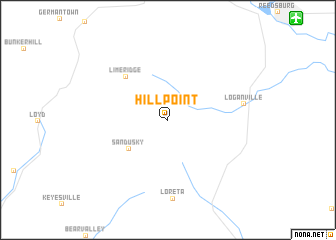
Hill Point (Wisconsin, United States - USA)Hill Point is a town in the Wisconsin region of United States - USA. An overview map of the region around Hill Point is displayed below.
regional and 3d topo map of Hill Point, United States - USA ::
Hill Point airports ::
The nearest airport is MSN - Madison Dane Co Rgnl Truax Fld, located 70.4 km south east of Hill Point.
Other airports nearby include GRB - Green Bay Austin Straubel Intl (198.0 km north east), Nearby towns ::
Sandusky (4.5km south west) //
Lime Ridge (5.9km north west) //
Loganville (6.4km east) //
Loreta (8.8km south) //
[all distances 'as the bird flies' and approximate]  Places with similar names to Hill Point, United States - USA ::
// Holly Pond (US)
// Holly Point (US)
// Holly Point (US)
// Holly Point (US)
// Halapunti (ID)
// Huayllapinto (PE)
// Huaillapunta (BO)
Disclaimer :: Information on this page comes without warranty of any kind |
||
|
Where is Hill Point? Elevation and coordinates ::
Latitude (lat): 43°25'28"N Longitude (lon): 90°6'45"W
Elevation (approx.): 302m (map arrows pan, magnifying glasses zoom) |
||
|
Visiting Hill Point? Hotel/Accommodation ::
Book a hotel in Hill Point Travel Guide ::
rental cars ::
car rental offers GPS waypoint ::
download a GPX waypoint (PoI) of Hill Point for your GPS receiver
|
||