|
search place name
|
||
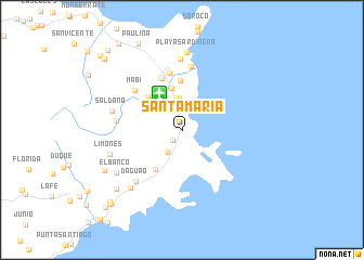
Santa Maria (Puerto Rico, United States - USA)Santa Maria is a town in the Puerto Rico region of United States - USA. An overview map of the region around Santa Maria is displayed below.
regional and 3d topo map of Santa Maria, United States - USA ::
Santa Maria airports ::
The nearest airport is FAJ - Fajardo Diego Jimenez Torres, located 4.3 km north west of Santa Maria.
Other airports nearby include SJU - San Juan Luis Munoz Marin Intl (42.2 km north west), SIG - San Juan Fernando Luis Ribas Dominicci (52.3 km north west), STT - St. Thomas Cyril E King (70.9 km east), PSE - Ponce Mercedita (102.0 km west), Nearby towns ::
Ceiba (1.4km south west) //
Aldea Cintron (2.7km north) //
Aguas Claras (2.7km south west) //
Luis M. Cintron (2.9km north) //
Luis Cintron (3.3km north) //
Fortuna (3.4km north) //
Josefa (4.4km north) //
San Pedro (4.6km north west) //
Vapor (4.8km north west) //
Quebrada Seca (4.9km south west) //
Santa Rita (5.0km north) //
Espanta Sueno (5.6km north) //
Fajardo (5.9km north) //
Mabi (6.2km north west) //
Playa de Fajardo (6.6km north) //
Paraiso (6.4km west) //
Daguao (6.9km south west) //
Isidra (7.3km north) //
Saldana (7.1km west) //
Limones (7.5km west) //
Playa Sardinera (8.0km north) //
Esperanza (7.9km south west) //
El Banco (7.8km south west) //
Mariana (8.6km south west) //
Hacienda Grande (8.8km south west) //
Paulina (9.9km north west) //
Estacion Botija (10.2km south west) //
Santiago y Lima (10.3km south west) //
Ramos (10.6km north west) //
[all distances 'as the bird flies' and approximate] 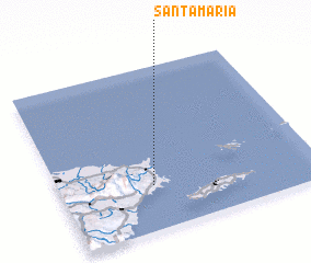 Places with similar names to Santa Maria, United States - USA ::
// Santa Maria (BR)
// Santa Maria (BR)
// Santa Maria (BR)
// Santa Maria (BR)
// Santa Maria (BR)
// Santa Maria (BR)
// Santa Maria (BR)
// Santa Maria (BR)
// Santa Maria (BR)
// Santa Maria (BR)
Disclaimer :: Information on this page comes without warranty of any kind |
||
|
Where is Santa Maria? Elevation and coordinates ::
Latitude (lat): 18°16'32"N Longitude (lon): 65°38'27"W
Elevation (approx.): 12m (map arrows pan, magnifying glasses zoom) |
||
|
Visiting Santa Maria? Hotel/Accommodation ::
Book a hotel in Santa Maria Travel Guide ::
rental cars ::
car rental offers GPS waypoint ::
download a GPX waypoint (PoI) of Santa Maria for your GPS receiver
|
||