|
search place name
|
||
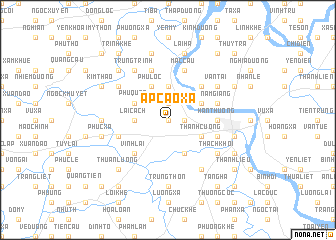
Ấp Cao Xá (Hải Hưng, Vietnam)Ấp Cao Xá is a town in the Hải Hưng region of Vietnam. An overview map of the region around Ấp Cao Xá is displayed below.
regional and 3d topo map of Ấp Cao Xá, Vietnam ::
Ấp Cao Xá airports ::
The nearest airport is HAN - Hanoi Noibai Intl, located 56.4 km north west of Ấp Cao Xá.
Other airports nearby include NNG - Nanning Wuxu (269.4 km north east), Nearby towns ::
Cao Xá (0.0km north) //
Hảo Hội (1.7km east) //
Hoàng Gia (1.9km north) //
Hương Trai (3.7km north) //
Lai Cách (3.5km west) //
Dương Quang (4.1km south east) //
Thanh Cương (3.9km south east) //
Hùng Thăng (3.9km north east) //
Ðông Hà (3.9km north east) //
Phú Lộc (4.1km north west) //
Ðức Trai (4.1km north west) //
Nga Hoang (4.1km north west) //
Phú Quân (3.9km north west) //
An Ðiềm (3.9km north west) //
Ngo Dinh (5.1km north east) //
Vĩnh Lại (5.1km south west) //
Dong Xa (5.1km south west) //
Hàn Thượng (5.2km east) //
Mặc Cầu (5.8km north) //
Hải Dương (5.5km east) //
Phúc Cầu (5.5km west) //
Nam Giang (5.5km east) //
Trinh Phú (5.8km north) //
Thạch Khôi (6.4km south east) //
Phú Triều (6.5km south east) //
Kim Ðôi (6.4km north west) //
Vạn Tải (6.4km north east) //
Thiên Khê (6.4km north east) //
Trung Trinh (6.5km north west) //
[all distances 'as the bird flies' and approximate]  Places with similar names to Ấp Cao Xá, Vietnam ::
// Ấp Cầu Xây (VN)
Disclaimer :: Information on this page comes without warranty of any kind |
||
|
Where is Ấp Cao Xá? Elevation and coordinates ::
Latitude (lat): 20°57'0"N Longitude (lon): 106°16'0"E
Elevation (approx.): 4m (map arrows pan, magnifying glasses zoom) |
||
|
Visiting Ấp Cao Xá? Hotel/Accommodation ::
Book a hotel in Ấp Cao Xá Travel Guide ::
Buy a travel guide for Vietnam rental cars ::
car rental offers GPS waypoint ::
download a GPX waypoint (PoI) of Ấp Cao Xá for your GPS receiver
|
||