|
search place name
|
||
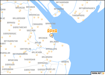
Ấp Hạ (Trà Vinh, Vietnam)Ấp Hạ is a town in the Trà Vinh region of Vietnam. An overview map of the region around Ấp Hạ is displayed below.
regional and 3d topo map of Ấp Hạ, Vietnam ::
Ấp Hạ airports ::
The nearest airport is SGN - Ho Chi Minh City Tansonnhat Intl, located 117.8 km north of Ấp Hạ.
Other airports nearby include PNH - Phnom-penh Phnom Penh Intl (269.5 km north west), Nearby towns ::
Ấp Lâm Rồ (2.5km south) //
Ấp Trung (3.4km north west) //
Ấp Cải Gia (3.5km west) //
Ấp Phú Thứ (4.2km north) //
Ấp Thạnh Phước (4.5km south east) //
Ấp Phú Long (5.0km south) //
Ấp Giồng Dài (5.1km south) //
Ô Lắc (5.2km south west) //
Ấp Lồ Ồ (5.8km south west) //
Ấp Bàu Bèo (5.9km south) //
Cẫm Hương (6.5km north west) //
Ấp Phú Thứ (7.5km north west) //
Sóc Chùa (7.7km west) //
Ấp Thủy Trùng (7.8km west) //
Ấp Mỹ Hội (7.9km west) //
Cầu Ngang (8.0km north west) //
Ấp Long Phi (8.1km south) //
Ấp Thủ Trước (8.2km north) //
Ấp Long Phô (8.4km south) //
Ấp Lạc Hòa (8.4km south west) //
Sóc Giụp (8.6km west) //
Ấp Hành Mỹ (8.7km north west) //
Ấp Ô Răng (8.7km west) //
Ấp Vĩnh Cữu (9.7km north west) //
Giồng Mõ Neơ (11.7km north east) //
Thiện Nghĩa (11.9km south west) //
[all distances 'as the bird flies' and approximate]  Places with similar names to Ấp Hạ, Vietnam ::
Disclaimer :: Information on this page comes without warranty of any kind |
||
|
Where is Ấp Hạ? Elevation and coordinates ::
Latitude (lat): 9°45'42"N Longitude (lon): 106°31'14"E
Elevation (approx.): -1m (map arrows pan, magnifying glasses zoom) |
||
|
Visiting Ấp Hạ? Hotel/Accommodation ::
Book a hotel in Ấp Hạ Travel Guide ::
Buy a travel guide for Vietnam rental cars ::
car rental offers GPS waypoint ::
download a GPX waypoint (PoI) of Ấp Hạ for your GPS receiver
|
||