|
search place name
|
||
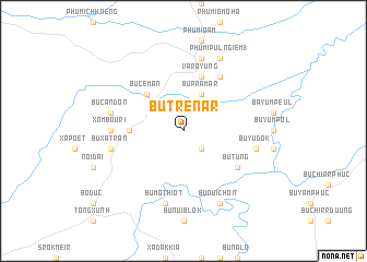
Bu Trênâr (Sông Bé, Vietnam)Bu Trênâr is a town in the Sông Bé region of Vietnam. An overview map of the region around Bu Trênâr is displayed below.
regional and 3d topo map of Bu Trênâr, Vietnam ::
Bu Trênâr airports ::
The nearest airport is SGN - Ho Chi Minh City Tansonnhat Intl, located 136.7 km south of Bu Trênâr.
Nearby towns ::
Bu Tun (2.6km south east) //
Bu Prámâr (4.1km north east) //
Bu Cêman (5.2km north west) //
Ấp Phước Thiện (1) (5.4km west) //
Varôyung (5.8km north) //
Bu Tung (6.6km south east) //
Phumĭ Pu Lngiĕm (2) (6.6km north east) //
Xóm Bouri (7.3km west) //
Bu Mo Thiôt (7.6km south) //
Bu Xa Trần (7.5km west) //
Bu Cần Ðơn (7.5km west) //
Bu Yu Dok (7.5km east) //
Phumĭ Leu (7.6km north) //
Bu Núi Choit (8.3km south east) //
Phumĭ Pu Lngiĕm (1) (8.3km north east) //
[all distances 'as the bird flies' and approximate] 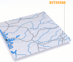 Places with similar names to Bu Trênâr, Vietnam :: Disclaimer :: Information on this page comes without warranty of any kind |
||
|
Where is Bu Trênâr? Elevation and coordinates ::
Latitude (lat): 12°2'0"N Longitude (lon): 106°53'0"E
Elevation (approx.): 148m (map arrows pan, magnifying glasses zoom) |
||
|
Visiting Bu Trênâr? Hotel/Accommodation ::
Book a hotel in Bu Trênâr Travel Guide ::
Buy a travel guide for Vietnam rental cars ::
car rental offers GPS waypoint ::
download a GPX waypoint (PoI) of Bu Trênâr for your GPS receiver
|
||