|
search place name
|
||
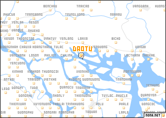
Dạo Tu (Hải Phòng, Vietnam)Dạo Tu is a town in the Hải Phòng region of Vietnam. An overview map of the region around Dạo Tu is displayed below.
regional and 3d topo map of Dạo Tu, Vietnam ::
Dạo Tu airports ::
The nearest airport is HAN - Hanoi Noibai Intl, located 92.1 km west of Dạo Tu.
Other airports nearby include NNG - Nanning Wuxu (235.2 km north east), Nearby towns ::
Sơn Liêu (1.7km west) //
Thượng Hạ Thung (2.5km north east) //
Mai Ðộng (2.5km south west) //
Hoành Mô (3.7km north) //
Lâm Xá (3.7km north) //
Chí Linh (3.5km west) //
Viên Khê (3.7km south) //
Yên Dương (3.9km north east) //
Dồn Sợn (3.9km north west) //
Dương Ðệ (3.9km north west) //
Quề Lạt (3.9km north west) //
Phuc Liêt (4.1km south east) //
Yên Lãng (5.1km north west) //
Tử Lạc (5.5km west) //
Dưỗng Dông (5.8km south) //
Như Ý Thượng (5.5km east) //
Mỹ Giáng (5.8km south) //
Tràng Bạch (6.4km north west) //
Dưỡng Chính (6.5km south west) //
Trại Kênh (7.4km south) //
Phi Liệt (6.9km west) //
Như Ý Trung (7.2km east) //
Bí Côn Thón (7.2km east) //
Hà Phu (7.6km south) //
Chúc Sơn (7.6km south) //
Thanh Lãng (7.6km south west) //
Bi Chõ (7.8km north east) //
Vĩnh Tuy (7.8km north west) //
Quảng Cư (8.2km south west) //
[all distances 'as the bird flies' and approximate] 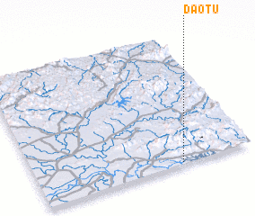 Places with similar names to Dạo Tu, Vietnam ::
Disclaimer :: Information on this page comes without warranty of any kind |
||
|
Where is Dạo Tu? Elevation and coordinates ::
Latitude (lat): 21°1'0"N Longitude (lon): 106°40'0"E
Elevation (approx.): 4m (map arrows pan, magnifying glasses zoom) |
||
|
Visiting Dạo Tu? Hotel/Accommodation ::
Book a hotel in Dạo Tu Travel Guide ::
Buy a travel guide for Vietnam rental cars ::
car rental offers GPS waypoint ::
download a GPX waypoint (PoI) of Dạo Tu for your GPS receiver
|
||