|
search place name
|
||
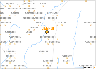
De Groi (Vietnam)De Groi is a town in Vietnam. An overview map of the region around De Groi is displayed below.
regional and 3d topo map of De Groi, Vietnam ::
De Groi airports ::
The nearest airport is NHA - Nhatrang, located 209.8 km south east of De Groi.
Nearby towns ::
De Panang Xobir (2) (1.9km south) //
De Panang Groi (3.7km south) //
De Chuk (4.0km south east) //
De Dak Trang (4.1km south east) //
De Tonouh Kotou (4.1km south east) //
De Blen Pok (5.2km north east) //
De Xol (5.2km north west) //
De Keung (5.7km west) //
De Toung (5.7km west) //
Plei Hơlim (5.8km north) //
Plei Yao (6.5km north east) //
De Klah (7.2km west) //
Dè Har Roh (7.6km south) //
De Koh (7.4km west) //
Plei Klah (7.6km north) //
Plei Tơdrah (7.6km north) //
Plei Trăng Klăh Bơt (7.7km north west) //
Plei Trăng Klăh Hơ Kiêng (7.7km north west) //
Plei Doc La (8.2km north east) //
Plei Trăng Klăh Kiuh (9.2km north west) //
[all distances 'as the bird flies' and approximate] 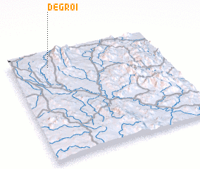 Places with similar names to De Groi, Vietnam ::
Disclaimer :: Information on this page comes without warranty of any kind |
||
|
Where is De Groi? Elevation and coordinates ::
Latitude (lat): 13°53'0"N Longitude (lon): 108°15'0"E
Elevation (approx.): 661m (map arrows pan, magnifying glasses zoom) |
||
|
Visiting De Groi? Hotel/Accommodation ::
Book a hotel in De Groi Travel Guide ::
Buy a travel guide for Vietnam rental cars ::
car rental offers GPS waypoint ::
download a GPX waypoint (PoI) of De Groi for your GPS receiver
|
||