|
search place name
|
||
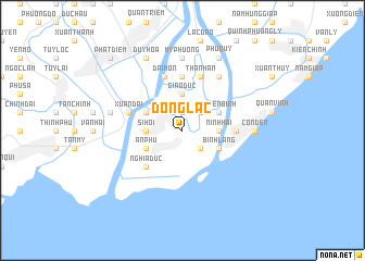
Ðồng Lạc (Vietnam)Ðồng Lạc is a town in Vietnam. An overview map of the region around Ðồng Lạc is displayed below.
regional and 3d topo map of Ðồng Lạc, Vietnam ::
Ðồng Lạc airports ::
The nearest airport is HAN - Hanoi Noibai Intl, located 136.7 km north of Ðồng Lạc.
Nearby towns ::
Chi Thiện (1.9km north) //
Con Van (2.5km south east) //
Giáo Lạc (2.5km north east) //
Ninh Hải (3.5km east) //
Sĩ Hội (3.5km west) //
Binh Hai Ly (3.7km north) //
Giáo Dực (3.7km north) //
Bình Lãng (3.9km south east) //
Thiên Bình (3.9km north east) //
An Phú (3.9km south west) //
Tra Trên (3.9km north west) //
Nghĩa Dục (5.1km south west) //
Giáo Phòng (5.6km north) //
Long Châu (5.2km east) //
Thành An (5.8km north) //
Ðài Mộn (5.8km north) //
Xuân Ðài (5.5km west) //
Phu Lễ Ấp (6.6km north east) //
Côn Dến (7.0km east) //
Mỹ Phuong (7.4km north) //
Tuy Ðịnh (7.2km west) //
Kim Dai (7.2km west) //
Phú Quý (8.2km north east) //
Duy Hòa (8.2km north west) //
Phát Diệm (10.2km north west) //
[all distances 'as the bird flies' and approximate] 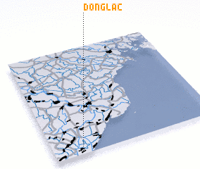 Places with similar names to Ðồng Lạc, Vietnam ::
Disclaimer :: Information on this page comes without warranty of any kind |
||
|
Where is Ðồng Lạc? Elevation and coordinates ::
Latitude (lat): 20°2'0"N Longitude (lon): 106°10'0"E
Elevation (approx.): 3m (map arrows pan, magnifying glasses zoom) |
||
|
Visiting Ðồng Lạc? Hotel/Accommodation ::
Book a hotel in Ðồng Lạc Travel Guide ::
Buy a travel guide for Vietnam rental cars ::
car rental offers GPS waypoint ::
download a GPX waypoint (PoI) of Ðồng Lạc for your GPS receiver
|
||