|
search place name
|
||
Ðông Lao (Vĩnh Phú, Vietnam)Ðông Lao is a town in the Vĩnh Phú region of Vietnam. An overview map of the region around Ðông Lao is displayed below.
regional and 3d topo map of Ðông Lao, Vietnam ::

Ðông Lao airports ::
The nearest airport is HAN - Hanoi Noibai Intl, located 65.1 km east of Ðông Lao.
Nearby towns ::
Gioc Lao (0.0km north) //
Thục Luyện (1.9km north) //
Xóm Tẩm (2.5km south west) //
Hoàng Trung (3.7km north) //
Lũng Chằn (3.7km south) //
Ðồng Giài (3.9km south east) //
Xóm Dinh (5.1km north west) //
Xóm Ma (5.1km south west) //
Xóm Giua (5.1km north east) //
Ðông Quân (5.8km north) //
Thanh Sơn (5.8km north) //
Làng Ria (5.8km south) //
Xóm Sem (5.5km east) //
Xóm Trai (5.5km west) //
Cự Bành (5.5km west) //
Hùng Nhĩ (5.8km north) //
Giáp Lai (6.4km north east) //
Xóm Gò Sui (6.4km south east) //
Lăng Khuê (7.4km north) //
Ðịch Quả (6.9km west) //
Bấn Chẩy (7.2km west) //
Hung Vĩ (7.6km north) //
Xóm Trang (7.2km west) //
Thiết Khoán (7.2km east) //
Thạch Khoán (7.2km east) //
Xóm Vung (7.6km south west) //
Ðồng Mu (7.6km south east) //
Cự Ðồng (8.2km south east) //
Ðông Quang (9.0km north west) //
[all distances 'as the bird flies' and approximate] 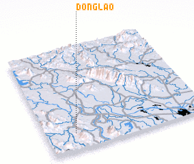 Places with similar names to Ðông Lao, Vietnam ::
Disclaimer :: Information on this page comes without warranty of any kind |
||
|
Where is Ðông Lao? Elevation and coordinates ::
Latitude (lat): 21°10'0"N Longitude (lon): 105°11'0"E
Elevation (approx.): 80m (map arrows pan, magnifying glasses zoom) |
||
|
Visiting Ðông Lao? Hotel/Accommodation ::
Book a hotel in Ðông Lao Travel Guide ::
Buy a travel guide for Vietnam rental cars ::
car rental offers GPS waypoint ::
download a GPX waypoint (PoI) of Ðông Lao for your GPS receiver
|
||