|
search place name
|
||
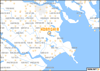
Hòa Nghĩa (Hải Phòng, Vietnam)Hòa Nghĩa is a town in the Hải Phòng region of Vietnam. An overview map of the region around Hòa Nghĩa is displayed below.
regional and 3d topo map of Hòa Nghĩa, Vietnam ::
Hòa Nghĩa airports ::
The nearest airport is HAN - Hanoi Noibai Intl, located 107.1 km north west of Hòa Nghĩa.
Other airports nearby include NNG - Nanning Wuxu (253.5 km north east), Nearby towns ::
An Toàn (1.7km east) //
Trung Hành (1.9km south) //
Tư Thủy (2.5km south east) //
Thái Lai (2.5km south east) //
Thu Du (2.5km south west) //
Cốc Liễn (2.5km south west) //
Cát Bi (3.7km north) //
Lão Phong (3.7km south) //
Dại Trà (3.8km north west) //
Ðúc Hậu (3.9km south east) //
Ta Ke (4.1km north west) //
Phan Dung (4.1km north west) //
Tiểu Trà (4.1km north west) //
Trà Khê (4.1km north west) //
Vọng Hải (3.9km north west) //
Thọ Linh (3.9km south west) //
Quí Kim (4.2km south east) //
Phúc Lộc (5.1km north west) //
Vân Quan (5.1km north west) //
Ngọc Liễn (5.1km south west) //
Ðông An (5.6km north) //
Ðộng Xá (5.6km north) //
Tam Kiệt (5.2km west) //
Hòc Thi (5.8km south) //
Ðồng Mô (5.8km south) //
Xâm Ðông (5.8km north) //
Trực Cát (5.8km north) //
Quang Luận (5.5km west) //
Xóm Niêm (5.8km north) //
[all distances 'as the bird flies' and approximate]  Places with similar names to Hòa Nghĩa, Vietnam ::
Disclaimer :: Information on this page comes without warranty of any kind |
||
|
Where is Hòa Nghĩa? Elevation and coordinates ::
Latitude (lat): 20°46'0"N Longitude (lon): 106°43'0"E
Elevation (approx.): 4m (map arrows pan, magnifying glasses zoom) |
||
|
Visiting Hòa Nghĩa? Hotel/Accommodation ::
Book a hotel in Hòa Nghĩa Travel Guide ::
Buy a travel guide for Vietnam rental cars ::
car rental offers GPS waypoint ::
download a GPX waypoint (PoI) of Hòa Nghĩa for your GPS receiver
|
||