|
search place name
|
||
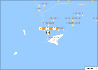
Hòn Chông (Kiến Giang, Vietnam)Hòn Chông is a town in the Kiến Giang region of Vietnam. An overview map of the region around Hòn Chông is displayed below.
regional and 3d topo map of Hòn Chông, Vietnam ::
Hòn Chông airports ::
The nearest airport is PNH - Phnom-penh Phnom Penh Intl, located 154.6 km north of Hòn Chông.
Nearby towns ::
Xóm Tà Lọp (0.0km north) //
Xóm Lò Vôi (2.6km north west) //
Xóm Ba Trại (2.6km south east) //
Ấp Núi Huỷnh (3.7km north) //
Xóm Mới (4.1km north east) //
Xóm Trà Ðuốc (4.1km north east) //
Ấp Rạch Ðùng (5.8km east) //
Xóm Núi Máy (5.9km north) //
[all distances 'as the bird flies' and approximate] 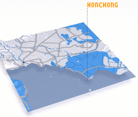 Places with similar names to Hòn Chông, Vietnam ::
// Huai'ancheng (CN)
// Han-ching (TW)
// Hoan Chung (VN)
// Hanchang (CN)
// Hanchang (CN)
// Hanchanggou (CN)
// Hancheng (CN)
// Hancheng (CN)
// Hancheng (CN)
// Henaoshang (CN)
Disclaimer :: Information on this page comes without warranty of any kind |
||
|
Where is Hòn Chông? Elevation and coordinates ::
Latitude (lat): 10°10'0"N Longitude (lon): 104°37'0"E
Elevation (approx.): 3m (map arrows pan, magnifying glasses zoom) |
||
|
Visiting Hòn Chông? Hotel/Accommodation ::
Book a hotel in Hòn Chông Travel Guide ::
Buy a travel guide for Vietnam rental cars ::
car rental offers GPS waypoint ::
download a GPX waypoint (PoI) of Hòn Chông for your GPS receiver
|
||