|
search place name
|
||
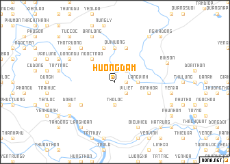
Hương Ðạm (Thanh Hóa, Vietnam)Hương Ðạm is a town in the Thanh Hóa region of Vietnam. An overview map of the region around Hương Ðạm is displayed below.
regional and 3d topo map of Hương Ðạm, Vietnam ::
Hương Ðạm airports ::
The nearest airport is HAN - Hanoi Noibai Intl, located 129.7 km north of Hương Ðạm.
Nearby towns ::
Dộng Bông (1.7km east) //
Ngọc Ðái (2.5km north east) //
Vĩ Liệt (2.5km south east) //
Thọ Lộc (3.7km south) //
Lãng Vịnh (3.5km east) //
Ngọc Trạo (5.1km north west) //
Qui Hương (5.6km north) //
Ðông Hậu (5.6km north) //
Phan Long (5.8km north) //
Gia Miên Nội (5.8km north) //
Bình Hòa (5.5km east) //
Bản Thủy (6.4km south west) //
Hòa Lễ (7.6km north west) //
Dị Chế (7.6km north west) //
Ðồng Ngư (7.9km north west) //
Ða Bút (7.9km south west) //
Ban Lông (8.2km north west) //
Biểu Hiệu (8.2km south east) //
Bỉm Sơn (8.6km east) //
Bồng Trung (8.9km south west) //
Thọ Trường (8.9km north west) //
Làng Hoàn (9.1km south west) //
Dũng Lươc (9.1km north east) //
Tuc Cốc (10.2km north west) //
Hà Trung (10.2km south east) //
Nghĩa Ðộng (10.2km north east) //
[all distances 'as the bird flies' and approximate] 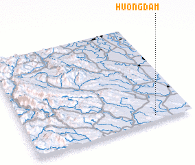 Places with similar names to Hương Ðạm, Vietnam ::
// Hengtam (IN)
// Hang Ðam (VN)
// Hoàng Ðàm (VN)
// Hanikatam (CN)
// Hongtumiao (CN)
// Huangdimiao (CN)
Disclaimer :: Information on this page comes without warranty of any kind |
||
|
Where is Hương Ðạm? Elevation and coordinates ::
Latitude (lat): 20°3'0"N Longitude (lon): 105°47'0"E
Elevation (approx.): 19m (map arrows pan, magnifying glasses zoom) |
||
|
Visiting Hương Ðạm? Hotel/Accommodation ::
Book a hotel in Hương Ðạm Travel Guide ::
Buy a travel guide for Vietnam rental cars ::
car rental offers GPS waypoint ::
download a GPX waypoint (PoI) of Hương Ðạm for your GPS receiver
|
||