|
search place name
|
||
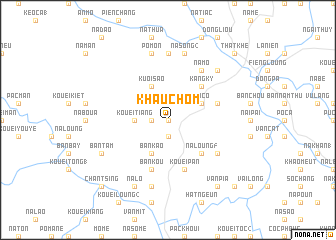
Khau Chôm (Lạng Sơn, Vietnam)Khau Chôm is a town in the Lạng Sơn region of Vietnam. An overview map of the region around Khau Chôm is displayed below.
regional and 3d topo map of Khau Chôm, Vietnam ::
Khau Chôm airports ::
The nearest airport is HAN - Hanoi Noibai Intl, located 124.5 km south west of Khau Chôm.
Other airports nearby include NNG - Nanning Wuxu (188.0 km east), Nearby towns ::
Ky Mua (0.0km north) //
Bản Chôm (1.9km south) //
Kao Tiang (1) (1.7km west) //
Kouei Tiang (3.4km west) //
Po Co (3.9km north east) //
Bản Kao (4.1km south west) //
Kuoi Sao (4.1km north west) //
Kouei To (5.1km south east) //
Na Loung (5) (5.1km south east) //
Kang Ky (5.1km north east) //
Kouei Pan (5.8km south) //
Bản Kouyen (5.5km east) //
Bản Kou (5.8km south) //
La Sớn (6.3km south east) //
Na Mo (6.5km north east) //
Bình Quân (7.4km north) //
Na Song (2) (7.6km north) //
Kouei Vay (7.6km south) //
Po Mon (7.6km north) //
Kouei Suỏi (7.6km north) //
Cao Phong (7.6km north east) //
Bản Tam (7.8km south west) //
Na Lo (8.2km south west) //
Van Pia (9.0km south east) //
Tĩnh Sóc (9.0km south east) //
Na Sa (10.1km south east) //
Hang Ma (10.1km north east) //
Thất Khê (10.1km north east) //
Chan Tsing (10.1km south west) //
[all distances 'as the bird flies' and approximate]  Places with similar names to Khau Chôm, Vietnam ::
Disclaimer :: Information on this page comes without warranty of any kind |
||
|
Where is Khau Chôm? Elevation and coordinates ::
Latitude (lat): 22°12'0"N Longitude (lon): 106°24'0"E
Elevation (approx.): 426m (map arrows pan, magnifying glasses zoom) |
||
|
Visiting Khau Chôm? Hotel/Accommodation ::
Book a hotel in Khau Chôm Travel Guide ::
Buy a travel guide for Vietnam rental cars ::
car rental offers GPS waypoint ::
download a GPX waypoint (PoI) of Khau Chôm for your GPS receiver
|
||