|
search place name
|
||
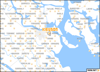
Kiều Sơn (Hải Phòng, Vietnam)Kiều Sơn is a town in the Hải Phòng region of Vietnam. An overview map of the region around Kiều Sơn is displayed below.
regional and 3d topo map of Kiều Sơn, Vietnam ::
Kiều Sơn airports ::
The nearest airport is HAN - Hanoi Noibai Intl, located 103.1 km north west of Kiều Sơn.
Other airports nearby include NNG - Nanning Wuxu (246.1 km north east), Nearby towns ::
Ðông Khê (1.4km south west) //
Phú Xá (1.7km east) //
Hạ Ðoạn (1.7km east) //
Binh Hai (1.9km north) //
Thượng Ðoạn (1.9km north) //
Trung Hành (1.9km south) //
Xâm Bồ (1.9km south) //
Lực Hánh (1.9km south) //
Ðoan Xá (1.8km north west) //
Hạ Ðoạn (2.5km south east) //
Hạ Lũng (2.5km south east) //
Lương Xâm (2.5km south east) //
Lũng Bắc (2.5km south east) //
An Khê (2.5km south west) //
Nam Pháp (2.5km south west) //
Bình Kiêu (3.5km east) //
Ðộng Xá (3.7km south) //
Ðông An (3.7km south) //
Hải Phòng (3.6km west) //
Trực Cát (4.1km south east) //
Xâm Ðông (4.1km south east) //
Hữu Quan (4.1km north west) //
Xóm Niêm (4.1km south west) //
Nga Ba (5.1km north west) //
Cát Bi (5.6km south) //
An Dương (5.2km west) //
Trà Khê (5.8km south) //
Tiểu Trà (5.8km south) //
Ta Ke (5.8km south) //
[all distances 'as the bird flies' and approximate] 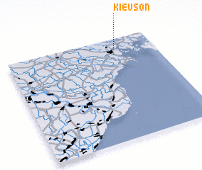 Places with similar names to Kiều Sơn, Vietnam ::
Disclaimer :: Information on this page comes without warranty of any kind |
||
|
Where is Kiều Sơn? Elevation and coordinates ::
Latitude (lat): 20°51'0"N Longitude (lon): 106°43'0"E
Elevation (approx.): 5m (map arrows pan, magnifying glasses zoom) |
||
|
Visiting Kiều Sơn? Hotel/Accommodation ::
Book a hotel in Kiều Sơn Travel Guide ::
Buy a travel guide for Vietnam rental cars ::
car rental offers GPS waypoint ::
download a GPX waypoint (PoI) of Kiều Sơn for your GPS receiver
|
||