|
search place name
|
||
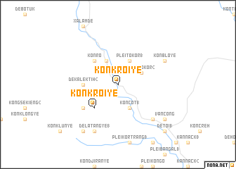
Kon Kroi Yé (Vietnam)Kon Kroi Yé is a town in Vietnam. An overview map of the region around Kon Kroi Yé is displayed below.
regional and 3d topo map of Kon Kroi Yé, Vietnam ::
Kon Kroi Yé airports ::
The nearest airport is DAD - Danang Intl, located 203.2 km north of Kon Kroi Yé.
Nearby towns ::
Kon Côt (1) (4.1km south east) //
Plei Tokor (2) (4.0km north east) //
Plei Tokor (1) (4.1km north east) //
Kon Rô (4.1km north west) //
Kon Kroi Ye (5.2km south west) //
Kon Ro (5.2km north west) //
De Kalek Tih (2) (5.4km west) //
De Kaleck Tih (1) (6.5km south west) //
Plei Man Ko (7.7km south east) //
De Latang Ye (1) (8.2km south west) //
Kon Blo Yé (8.1km north east) //
De Latang Ye (2) (9.2km south west) //
Văn Công (9.1km south east) //
De Toï (1) (10.3km south east) //
[all distances 'as the bird flies' and approximate] 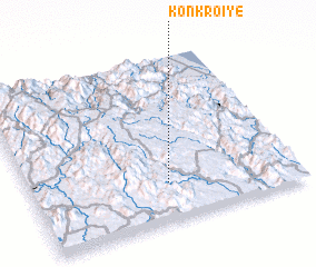 Places with similar names to Kon Kroi Yé, Vietnam ::
Disclaimer :: Information on this page comes without warranty of any kind |
||
|
Where is Kon Kroi Yé? Elevation and coordinates ::
Latitude (lat): 14°14'0"N Longitude (lon): 108°31'0"E
Elevation (approx.): 589m (map arrows pan, magnifying glasses zoom) |
||
|
Visiting Kon Kroi Yé? Hotel/Accommodation ::
Book a hotel in Kon Kroi Yé Travel Guide ::
Buy a travel guide for Vietnam rental cars ::
car rental offers GPS waypoint ::
download a GPX waypoint (PoI) of Kon Kroi Yé for your GPS receiver
|
||