|
search place name
|
||
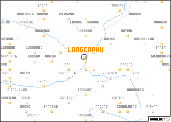
Làng Ca Phu (Cao Bằng, Vietnam)Làng Ca Phu is a town in the Cao Bằng region of Vietnam. An overview map of the region around Làng Ca Phu is displayed below.
regional and 3d topo map of Làng Ca Phu, Vietnam ::
Làng Ca Phu airports ::
The nearest airport is HAN - Hanoi Noibai Intl, located 176.9 km south of Làng Ca Phu.
Nearby towns ::
Na Pong (2) (NaNkm north) //
Na Vuong (1.9km south) //
Bo Vat (2.5km south east) //
Na Ma Len (2.5km north east) //
Na Ri (3.9km south west) //
Bản Loung (5.0km south west) //
Kheo Kha (5.6km north) //
Kouei Khau (5.5km west) //
Bản Pon (6.5km south east) //
Phia Hien (6.3km south east) //
Bac Mio (6.3km north east) //
Tan Kuay (7.4km south) //
Pia Làp (6.8km west) //
Kouei Loung (6.8km west) //
Bản Tan (2) (7.6km south) //
Na Heo (7.1km east) //
Co Rang (7.6km north) //
Na Bang (7.6km north) //
[all distances 'as the bird flies' and approximate]  Places with similar names to Làng Ca Phu, Vietnam ::
// Làng Cai Phó (VN)
// Làng Ky Phá (VN)
Disclaimer :: Information on this page comes without warranty of any kind |
||
|
Where is Làng Ca Phu? Elevation and coordinates ::
Latitude (lat): 22°47'0"N Longitude (lon): 105°27'0"E
Elevation (approx.): 176m (map arrows pan, magnifying glasses zoom) |
||
|
Visiting Làng Ca Phu? Hotel/Accommodation ::
Book a hotel in Làng Ca Phu Travel Guide ::
Buy a travel guide for Vietnam rental cars ::
car rental offers GPS waypoint ::
download a GPX waypoint (PoI) of Làng Ca Phu for your GPS receiver
|
||