|
search place name
|
||
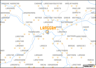
Làng Gàm (Thanh Hóa, Vietnam)Làng Gàm is a town in the Thanh Hóa region of Vietnam. An overview map of the region around Làng Gàm is displayed below.
regional and 3d topo map of Làng Gàm, Vietnam ::
Làng Gàm airports ::
The nearest airport is HAN - Hanoi Noibai Intl, located 156.1 km north of Làng Gàm.
Nearby towns ::
Ðồn Sơn (1.7km west) //
Làng Quan (1.9km north) //
Làng Ma (2) (2.5km south west) //
Làng Ao (2.5km south east) //
Làng Ho (2.5km south east) //
Làng Lau (2.5km north east) //
Làng Ngam (3.7km north) //
Làng Mo (3.9km south west) //
Làng Cau (4.1km south east) //
Làng Hạ (1) (3.9km north east) //
Bái Ðô (3.9km north east) //
Làng Ðồng (3.9km north east) //
Làng Hô (3.9km north east) //
Luận Vãn (3.9km north east) //
Làng Lú (5.1km south east) //
Làng Rach (5.2km east) //
Châu Thộn (5.6km north) //
Làng Nhiêm (5.2km west) //
Làng Dinh (5.2km west) //
Thường Xuân (5.2km west) //
Làng Ca (5.8km south) //
Cốc Thượng (5.8km north) //
Bái Thượng (5.5km east) //
Làng Thôn (5.8km north) //
Làng Bai (6.4km south east) //
Mé Trên (6.6km north west) //
Thủ Trinh (6.6km north east) //
Làng Thiêu (7.0km west) //
Làng Tion (7.0km west) //
[all distances 'as the bird flies' and approximate] 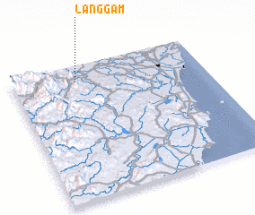 Places with similar names to Làng Gàm, Vietnam ::
Disclaimer :: Information on this page comes without warranty of any kind |
||
|
Where is Làng Gàm? Elevation and coordinates ::
Latitude (lat): 19°53'0"N Longitude (lon): 105°20'0"E
Elevation (approx.): 33m (map arrows pan, magnifying glasses zoom) |
||
|
Visiting Làng Gàm? Hotel/Accommodation ::
Book a hotel in Làng Gàm Travel Guide ::
Buy a travel guide for Vietnam rental cars ::
car rental offers GPS waypoint ::
download a GPX waypoint (PoI) of Làng Gàm for your GPS receiver
|
||