|
search place name
|
||
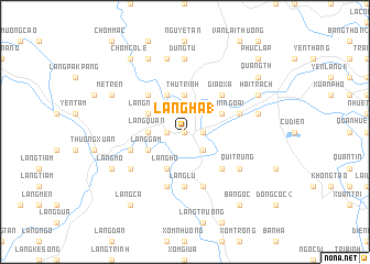
Làng Hạ (1) (Thanh Hóa, Vietnam)Làng Hạ (1) is a town in the Thanh Hóa region of Vietnam. An overview map of the region around Làng Hạ (1) is displayed below.
regional and 3d topo map of Làng Hạ (1), Vietnam ::
Làng Hạ (1) airports ::
The nearest airport is HAN - Hanoi Noibai Intl, located 153.3 km north of Làng Hạ (1).
Nearby towns ::
Làng Hô (NaNkm north) //
Luận Vãn (NaNkm north) //
Bái Ðô (NaNkm north) //
Làng Ðồng (NaNkm north) //
Bái Thượng (1.7km east) //
Làng Lau (1.7km west) //
Làng Rach (2.5km south east) //
Thủ Trinh (3.7km north) //
Làng Quan (3.5km west) //
Làng Ho (4.1km south west) //
Làng Ao (4.1km south west) //
Làng Thôn (4.1km north west) //
Cốc Thượng (4.1km north west) //
Mục Sơn Nội (3.9km north east) //
Mục Sơn Ngoại (3.9km north east) //
Làng Gàm (3.9km south west) //
Làng Ngam (3.9km north west) //
Ðá Rưng (5.1km south east) //
Ðồng Tro (5.1km south east) //
Giao Xá (5.1km north east) //
Châu Thộn (5.1km north west) //
Làng Lú (5.6km south) //
Làng Bai (5.8km south) //
Ðồn Sơn (5.5km west) //
Làng Cau (5.8km south) //
Giao Xá (5.5km east) //
Làng Ma (2) (6.4km south west) //
Quí Trung (6.4km south east) //
Chòm Bống (7.4km north) //
[all distances 'as the bird flies' and approximate] 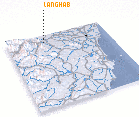 Places with similar names to Làng Hạ (1), Vietnam ::
// Langhub (PH)
// Lai Nghi (1) (VN)
// Làng Hoa (1) (VN)
// Làng Ho (1) (VN)
// Lũng Hoai (1) (VN)
// Lũng Hoài (1) (VN)
// Lianghuiba (CN)
Disclaimer :: Information on this page comes without warranty of any kind |
||
|
Where is Làng Hạ (1)? Elevation and coordinates ::
Latitude (lat): 19°54'0"N Longitude (lon): 105°22'0"E
Elevation (approx.): 25m (map arrows pan, magnifying glasses zoom) |
||
|
Visiting Làng Hạ (1)? Hotel/Accommodation ::
Book a hotel in Làng Hạ (1) Travel Guide ::
Buy a travel guide for Vietnam rental cars ::
car rental offers GPS waypoint ::
download a GPX waypoint (PoI) of Làng Hạ (1) for your GPS receiver
|
||