|
search place name
|
||
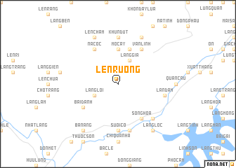
Len Ruong (Lạng Sơn, Vietnam)Len Ruong is a town in the Lạng Sơn region of Vietnam. An overview map of the region around Len Ruong is displayed below.
regional and 3d topo map of Len Ruong, Vietnam ::
Len Ruong airports ::
The nearest airport is HAN - Hanoi Noibai Intl, located 79.7 km south west of Len Ruong.
Other airports nearby include NNG - Nanning Wuxu (208.9 km north east), Nearby towns ::
Làng Gia (4.1km north east) //
Làng Lôi (3.9km south west) //
Mo Cây (5.6km north) //
Khon Lung Na (5.8km north) //
Vạn Linh (6.5km north east) //
Ba Lương (6.5km south east) //
Lân Ðinh (6.5km south east) //
Song Hoa (6.5km south east) //
Na Coc (6.5km north west) //
Bai Ðanh (6.4km south west) //
Khun Dut (7.4km north) //
Suối Cô (7.4km south) //
Lân Ðâm (7.1km east) //
Hòa Lạc (7.6km south) //
Ðông Hương (7.6km south east) //
Khon Lung Om (8.2km north east) //
Len Cham (8.2km north west) //
Ba Nang (9.0km south west) //
Cao Nung (9.0km south east) //
Làng Lộc (9.0km south east) //
[all distances 'as the bird flies' and approximate] 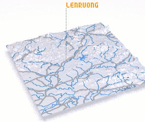 Places with similar names to Len Ruong, Vietnam ::
Disclaimer :: Information on this page comes without warranty of any kind |
||
|
Where is Len Ruong? Elevation and coordinates ::
Latitude (lat): 21°37'0"N Longitude (lon): 106°27'0"E
Elevation (approx.): 369m (map arrows pan, magnifying glasses zoom) |
||
|
Visiting Len Ruong? Hotel/Accommodation ::
Book a hotel in Len Ruong Travel Guide ::
Buy a travel guide for Vietnam rental cars ::
car rental offers GPS waypoint ::
download a GPX waypoint (PoI) of Len Ruong for your GPS receiver
|
||