|
search place name
|
||
Ngai Thào Sang (Vietnam)Ngai Thào Sang is a town in Vietnam. An overview map of the region around Ngai Thào Sang is displayed below.
regional and 3d topo map of Ngai Thào Sang, Vietnam ::
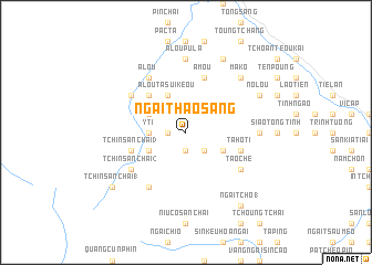
Nearby towns ::
Phan Kơng Su (1.9km south) //
Hờ Kung Mừng (1.7km west) //
Ngai Chò (1.7km west) //
Hờ Ngai Tụng (2.5km south east) //
Ý Tí (3.4km west) //
A Lou Ta Sui Keou (4.1km north west) //
Ta Ho Ti (3.9km south east) //
Chin Chư Lin (3.9km north west) //
Sin Chải (3.9km south west) //
Ta Pin Chải (5.0km north west) //
A Mou (5.8km north) //
Tchin San Chai (3) (5.5km west) //
Ta Ho Ti (5.5km east) //
Mao Tao Sang (6.3km north west) //
A Lou (6.5km north west) //
Nìu Cò San Chai (6.5km south west) //
Tao Che (6.3km south east) //
Tchin San Chai (2) (6.3km south west) //
A Lou Pu La (7.4km north) //
Pin Long Ho (6.8km east) //
Pan Chan (6.8km east) //
Ma Ko (7.6km north east) //
No Lou (7.8km north east) //
Ma Ko Pou La Tiai (8.2km north east) //
Ngai Tcho (1) (9.0km south east) //
Tchin San Chai (1) (8.8km south west) //
[all distances 'as the bird flies' and approximate] 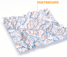 Places with similar names to Ngai Thào Sang, Vietnam :: Disclaimer :: Information on this page comes without warranty of any kind |
||
|
Where is Ngai Thào Sang? Elevation and coordinates ::
Latitude (lat): 22°40'0"N Longitude (lon): 103°37'0"E
Elevation (approx.): 1649m (map arrows pan, magnifying glasses zoom) |
||
|
Visiting Ngai Thào Sang? Hotel/Accommodation ::
Book a hotel in Ngai Thào Sang Travel Guide ::
Buy a travel guide for Vietnam rental cars ::
car rental offers GPS waypoint ::
download a GPX waypoint (PoI) of Ngai Thào Sang for your GPS receiver
|
||