|
search place name
|
||
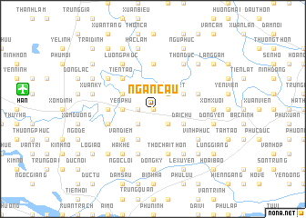
Ngân Cẩu (Hà Bắc, Vietnam)Ngân Cẩu is a town in the Hà Bắc region of Vietnam. An overview map of the region around Ngân Cẩu is displayed below.
regional and 3d topo map of Ngân Cẩu, Vietnam ::
Ngân Cẩu airports ::
The nearest airport is HAN - Hanoi Noibai Intl, located 15.0 km west of Ngân Cẩu.
Nearby towns ::
Phú Mẫn (0.0km north) //
Yên Phụ Hậu (1.7km west) //
Phù Lưu (2.5km south east) //
Ngộ Nội (2.5km south east) //
Ngõ Nui (2.5km south west) //
Vọng Nguyệt (2.5km north east) //
Ðồng Nhân (3.5km west) //
Yên Phú (3.5km west) //
Ðại Chu (3.9km south east) //
Mai Hạ (3.9km north east) //
Ngoai Thôn (4.1km south west) //
Duyên Lộc (3.9km north west) //
Vạn Diểm (5.1km south west) //
Tiên Tảo (5.1km north west) //
Kim Lũ (5.2km west) //
Xuân Lai (5.2km west) //
Giáp Nguyên (5.6km north) //
Thụy Lôi (5.5km west) //
Vọng Ðông (5.5km east) //
Tho Chai Thôn (5.8km south) //
Hương Mặc (5.8km south) //
Vĩnh Phục (6.4km south east) //
Phúc Tinh (6.5km south east) //
Thôn Duc (6.5km north east) //
Ðức Hậu (6.4km north west) //
Hà Khê (6.5km south west) //
Lương Phúc (6.5km north west) //
Ðồng Ky (7.4km south) //
Xóm Xuôi (6.9km east) //
[all distances 'as the bird flies' and approximate] 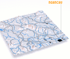 Places with similar names to Ngân Cẩu, Vietnam ::
Disclaimer :: Information on this page comes without warranty of any kind |
||
|
Where is Ngân Cẩu? Elevation and coordinates ::
Latitude (lat): 21°12'0"N Longitude (lon): 105°57'0"E
Elevation (approx.): 6m (map arrows pan, magnifying glasses zoom) |
||
|
Visiting Ngân Cẩu? Hotel/Accommodation ::
Book a hotel in Ngân Cẩu Travel Guide ::
Buy a travel guide for Vietnam rental cars ::
car rental offers GPS waypoint ::
download a GPX waypoint (PoI) of Ngân Cẩu for your GPS receiver
|
||