|
search place name
|
||
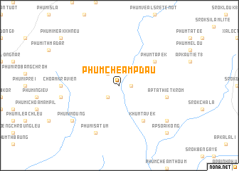
Phum Chéam Pdau (Sông Bé, Vietnam)Phum Chéam Pdau is a town in the Sông Bé region of Vietnam. An overview map of the region around Phum Chéam Pdau is displayed below.
regional and 3d topo map of Phum Chéam Pdau, Vietnam ::
Phum Chéam Pdau airports ::
The nearest airport is SGN - Ho Chi Minh City Tansonnhat Intl, located 107.9 km south of Phum Chéam Pdau.
Other airports nearby include PNH - Phnom-penh Phnom Penh Intl (173.2 km west), Nearby towns ::
Phum Por (1.8km east) //
Phumĭ Stœ̆ng Srei (2.6km north west) //
Phumĭ Lvéa (2.6km south west) //
Khum Tavek (6.6km south east) //
Phum Tapek (6.6km north east) //
Ấp Ta Thiêt Krom (7.5km east) //
Phumĭ Satum (8.3km south west) //
Ấp Tuk Chât (9.1km south east) //
Phumĭ Moŭng (9.1km south west) //
Ấp Soai Kong (10.4km south east) //
[all distances 'as the bird flies' and approximate]  Places with similar names to Phum Chéam Pdau, Vietnam :: Disclaimer :: Information on this page comes without warranty of any kind |
||
|
Where is Phum Chéam Pdau? Elevation and coordinates ::
Latitude (lat): 11°46'0"N Longitude (lon): 106°25'0"E
Elevation (approx.): 49m (map arrows pan, magnifying glasses zoom) |
||
|
Visiting Phum Chéam Pdau? Hotel/Accommodation ::
Book a hotel in Phum Chéam Pdau Travel Guide ::
Buy a travel guide for Vietnam rental cars ::
car rental offers GPS waypoint ::
download a GPX waypoint (PoI) of Phum Chéam Pdau for your GPS receiver
|
||