|
search place name
|
||
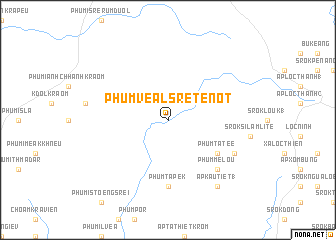
Phum Véal Sré Tenot (Sông Bé, Vietnam)Phum Véal Sré Tenot is a town in the Sông Bé region of Vietnam. An overview map of the region around Phum Véal Sré Tenot is displayed below.
regional and 3d topo map of Phum Véal Sré Tenot, Vietnam ::
Phum Véal Sré Tenot airports ::
The nearest airport is SGN - Ho Chi Minh City Tansonnhat Intl, located 117.7 km south of Phum Véal Sré Tenot.
Other airports nearby include PNH - Phnom-penh Phnom Penh Intl (180.4 km west), Nearby towns ::
Phum Tatée (6.6km south east) //
Phum Tapek (7.4km south) //
Phum Melou (7.8km south east) //
Phnom Tiem Pring (2) (8.1km south east) //
Ấp Kau Tiet (1) (9.2km south east) //
[all distances 'as the bird flies' and approximate]  Places with similar names to Phum Véal Sré Tenot, Vietnam :: Disclaimer :: Information on this page comes without warranty of any kind |
||
|
Where is Phum Véal Sré Tenot? Elevation and coordinates ::
Latitude (lat): 11°52'0"N Longitude (lon): 106°28'0"E
Elevation (approx.): 67m (map arrows pan, magnifying glasses zoom) |
||
|
Visiting Phum Véal Sré Tenot? Hotel/Accommodation ::
Book a hotel in Phum Véal Sré Tenot Travel Guide ::
Buy a travel guide for Vietnam rental cars ::
car rental offers GPS waypoint ::
download a GPX waypoint (PoI) of Phum Véal Sré Tenot for your GPS receiver
|
||